Natural History of the Eastern Sierra
“If you truly love nature, you will find beauty everywhere.” ~ Vincent van Gogh.
Welcome to our Natural History page, where you can take a quick virtual visit to the many intriguing places in our beautiful big backyard.

Starry, starry night in the Eastern Sierra. Photo: @exploreabitmore
There are few places in the world where evidence of the natural history of a region is more obvious and interesting than in the Eastern Sierra. The forces that have shaped our world have produced an astonishing assortment of observable characteristics that give us insight into the creation of this part of our planet. These distinctive features present an opportunity to view, firsthand, the results of these forces. Aspects of nature that seem improbable and unexpected are wonderous and beautiful. Elements of geography and topography that appear inconsistent and disrupted have logical explanations. Everything here has happened for a reason and we are witness to the wonder of nature.
Scholars and researchers from around the world travel to the Eastern Sierra to study aspects of our natural history in a variety of fields. Their findings are often well regarded and published in scholarly journals and the media at large.

The Sailing Stones, Racetrack, Death Valley National Park
One such fascinating study proved, after many years of speculation, why the ‘sailing stones’ on the Racetrack in Death Valley move – seemingly by magic. It was a remarkable experiment using sophisticated technology which proved conclusively that a rare set of weather conditions move large rocks across a flat, desert playa without any human interference whatsoever. It is a rare event that is seldom witnessed by people when it happens, but the remaining evidence of their unseen movement is obvious for all who visit the playa to see.
Many regular visitors to our region spend time in the same places and report that it is very rewarding to find consistency in our natural world. Others are committed to exploration and challenge; the extensive opportunities here provide a constant supply of fresh landscapes and hidden treasures to seek out. All who venture into the known and unknown say it is exciting and rejuvenating.
Whether you are a frequent guest or first-time visitor this page can guide you to the places that excite you most. It may offer something new or confirm a feeling you have for a special place that you know and love. It might just open a window to a whole new experience that you’ve never considered before. Wherever this takes you, we encourage you to find out more by following the links and reaching out to us.
Our visitor center staff have so much information and experience to share with our guests, that visitors to our region usually start right here in Bishop to learn more and plan their best vacations and getaways in the Eastern Sierra. We have giveaways, excellent maps, tips and tricks, and information on best practices for all our guests. We welcome you and encourage you to visit often and let us know about your fun and findings in the Eastern Sierra.
Some general information about the natural history of the Eastern Sierra.
Click on the toggle bars below for more general details about our natural world.
Where & Why

Fall colors at North Lake near Bishop
The region is on the eastern side of the Sierra Nevada mountain range that divides much of central California into the wetter western side and the drier eastern side. The Eastern Sierra is made up primarily of two counties, Inyo and Mono. Inyo County, the second largest county by area in California, and its northern neighbor Mono County (pronounced moh-no) are two of the least populated counties in California. Together these two counties cover just under 10% of the total land area of all of California. A staggering 99% of land in Inyo County and 93.6% of Mono County is designated as public lands. This adds up to an incredible amount of beautiful and diverse land for adventure and exploration.
The Eastern Sierra is a pristine and diverse landscape of deserts and sand dunes, huge mountains and alpine forests, meandering rivers and tumbling waterfalls, spectacular sunsets, spring wildflowers and fabulous fall colors. It ranks as one of the most photographed regions in the USA.
Bishop is the largest town along the highway corridor that runs through the Eastern Sierra and it’s situated pretty much right in the middle of the region. Death Valley National Park is a little over 150 miles south (almost all of it entirely within Inyo County) and the gateway to Yosemite National Park is a little under 150 miles north.
We like to say it’s, “Halfway between heaven and, well … heaven!”
What & Who

Great Basin Bristlecone Pines. Photo: @richmophoto
The Eastern Sierra is a vast and unspoiled region that offers exceptional opportunity for recreation and discovery. Whether you are trekking along the John Muir Trail or wandering among the ancient Great Basin Bristlecone pines or watching the Milky Way arc brilliantly across the sky on a dark moonless night, there’s a story there that goes back to the dawn of history.
The rocks tell stories of the upheavals of the earth, and the valley shows where the Earth’s crust has stretched and dropped while the mountains rose to shelter it from storms. Tiny fish and wild bighorn sheep, a million-year old lake and the planet’s oldest living things, all endemic to this region, survive, protected by their stewards, so that we can learn about our past and perhaps secure our future.
Current land management and the practices of land stewardship are preserving and conserving this land and safeguarding its history. We are all the keepers of our past and the protectors of our future. Participate in the present by visiting, learning, photographing, cherishing, and sharing your story and our collective history.
We love our big backyard, which has been much like this for eons. We encourage everyone to enjoy its wonderful wild beauty and to take the pledge to Protect. Preserve. Participate. Perpetuate.
When & How
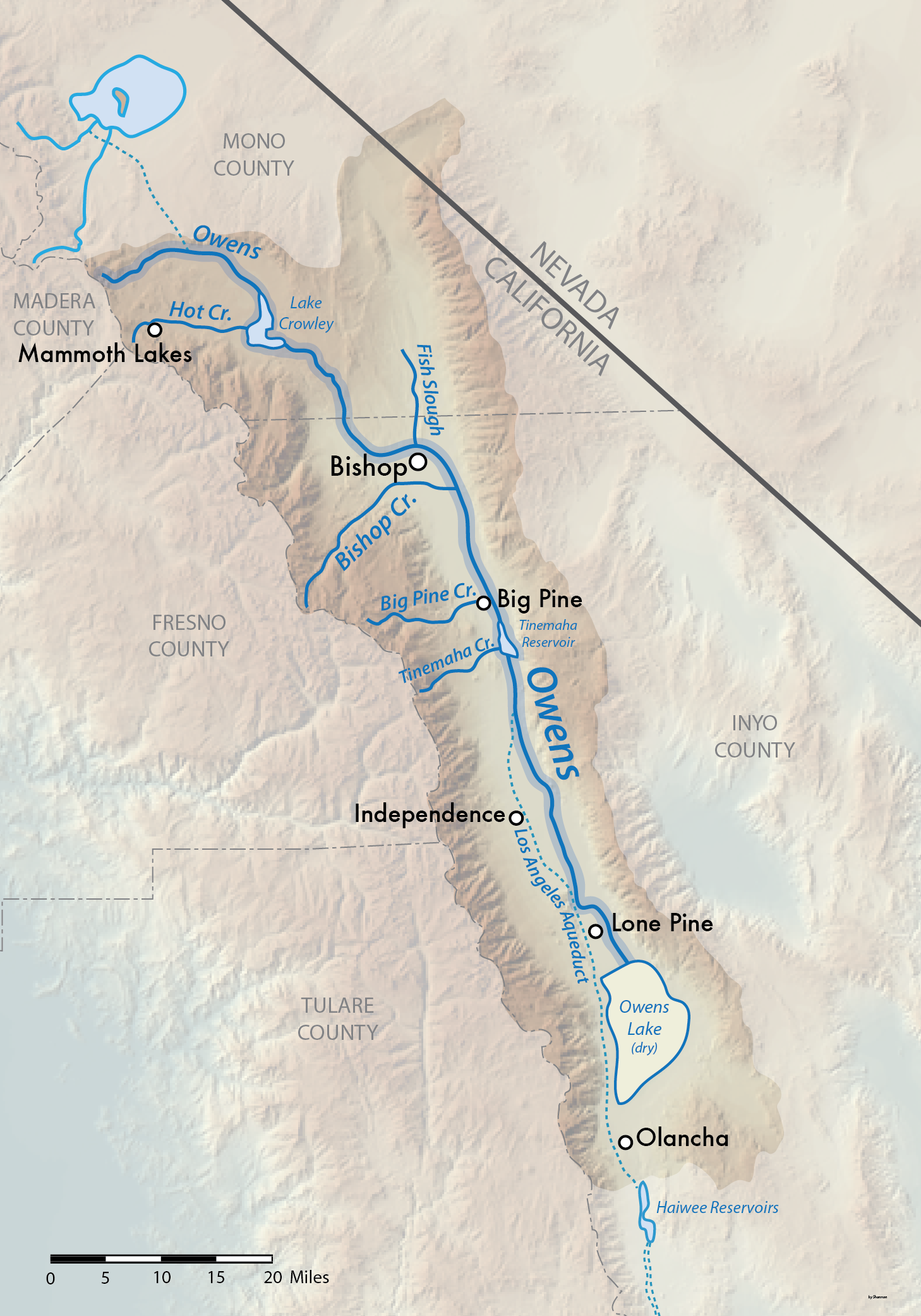
Owens River Map by Shannon01 Wikimedia Commons
This land, before time was measured and records were kept, was very different to what we see today. What is now the western USA was once separated from what is today the eastern USA by a massive inland sea. Huge marine reptiles swam in this ocean and their fossil remains can be viewed at a nearby Nevada State Park, the Berlin-Ichthyosaur State Park.
As the region dried, and the earth lifted and dropped and exploded, it developed into what we see today. It continues to crack, and warp, and shape our landscape. The Eastern Sierra, unlike so many other primordial lands of the world, remains relatively untouched by human interference. It is still wild and diverse, with massive mountains and deep valleys.
The first people who roamed and lived in this region are believed to have been here for at least 10,000 years. They treated the land with respect and learned to live with its changes and vagaries. The first white explorers arrived in the Eastern Sierra a little less than 200 years ago. One of the earliest explorers of the region was famed mountain man, Jedediah Smith, in 1826. Some years later in 1834, Joseph Walker, reconnoitered the region and Walker Lake in Nevada is named after him.
In late 1845, Col. John C Fremont along with trusted guide, Kit Carson, and reputable cartographer, Edward Kern, ventured into the region now known as the Owens Valley. The expedition began near Walker Lake, Nevada and moved west then south along the eastern flank of the Sierra Nevada. They came upon the headwaters of a river and followed it to its terminus in a large lake. Fremont name this lake, Owens Lake, for another of his most trusted guides, Richard Owens, even though Owens was not a member of this party. The river became known as the Owens River and much later the entire valley was named the Owens Valley. He named several other lakes and creeks for members of the party. Only Owens and the Kern River in what is today Kern County have retained these early names.
In 1861, Samuel Addison Bishop, arrived with his wife, several hired hands, an impressive herd of 600 cattle, and 50 horses to settle in the Owens Valley. They established a homestead, the San Francis Ranch, alongside a creek which still bears his name today – Bishop Creek. Within a year, a few miles east of the ranch, the frontier settlement of Bishop Creek became a town and is today the City of Bishop in Inyo County, California.
Today, explorers and residents still marvel at the beauty and revel in the abundance of the Eastern Sierra. It is said by locals, that the Eastern Sierra is so vast that there is a lifetime of exploration available here, “You could live here your whole life, explore a different place each day, and never run out of something new to see.”
Read more about people and things in these companion pages, Cultural History and Museums.
Whenever you visit the Eastern Sierra and wherever you go … find its history then tell your story.
Links & Things
There are so many fascinating places to see and things to learn about the Eastern Sierra. We have tons of great information on our website that will open up other avenues of learning and opportunities for recreation. Take a look at some of these guide pages and previous blog posts.
Hotspot map of Natural History in the Eastern Sierra
The round icons show where to find the many fascinating features of the Eastern Sierra. Scroll down to read details about each feature shown on this map.

Natural History Hotspots
Fossil Falls

Smoothly shaped volcanic rock of Fossil Falls
This geological wonder is a magnificent example of the forces of nature that shape our world. Technically it’s not a fossil and water no longer falls here in any abundance. This surreal canyon of basaltic black lava rock is now a natural work of art, beautifully sculpted by eons of rushing water from a prehistoric age. Early inhabitants lived along the banks when water once flowed down this ancient river. Artifacts and rock art indicate a viable hunter-gatherer culture existed here some 10,000 to 20,000 years ago.
The chasm is almost unnoticeable in the flat lands of the valley floor from a distance. But up close it unfurls in folds of glossy, black rock that are both beautiful and strange. The rock is smooth and shiny and distinctly different from the surrounding landscape. It is stark evidence of a time when the valley was wetter and of the inevitability of change.
It is easily accessed from US Highway 395 just 5-miles south of Coso Junction along a one-mile dirt road and then a short walk of less than ¼-mile to the mouth of the crevasse.

Deep crevasse of Fossil Falls. Notice person near top center for scale.
jump back to map
Jump to related topics: #owensvalley #sierranevada #owensriver
Death Valley

Death Valley superbloom.
Despite its macabre name, this monumental landscape is strikingly beautiful and does, in fact, sustain a large variety of life. The sheer size and diversity of its terrain creates opportunity for plants, animals and insects to survive and thrive in a seemingly hostile environment.
The ancient natural history of this valley is presented in a strikingly visual display of extremes. Tall mountains, snow-capped in winter, flank deep rift valleys with windswept sand dunes that rise and fall across the plains below. Rugged canyons etched by eons of wind and water reveal layers of rock in a rainbow of earthy colors. Massive craters in the alluvial fans, draped across the valley floor, are surreal evidence of recent volcanic activity. Parched earth erupts in a bloom of wildflowers after infrequent rainstorms flood the plains and nourish the dormant seeds. This is a primordial land of contrasts and superlatives.
Death Valley National Park covers 3,000 square miles of southeastern Inyo County. The lowest point on the North American continent is here at 282 feet below sea level. It is known as Badwater Basin. It’s not the lowest point on the earth, but ranks at number 8 on the list of “lowest exposed land on the earth’s surface.” The summer heat is intense and the salty water is undrinkable, and yet it is home to an amazing number of tiny plants, animals and aquatic insects.
This vast, flat salt pan is starkly beautiful with high mountains rising up on either side. A marker on the nearby cliffside shows where sea level is, way above where visitors stand to gaze or walk out on this seemingly desolate, white expanse.

Badwater Basin.
Furnace Creek, the tourism hub of this magnificent national park was originally a mining settlement known as Greenland Ranch. Natural springs feed the many creeks that seep and flow through the park and it is this perennial water source that allowed for large alfalfa fields to grow here in the late 1800s – hence its original name of Greenland Ranch. The spot holds the distinction of having the highest ever recorded temperature on earth. On the afternoon of July 10, 1913, the ambient air temperature was recorded at a blistering 134.1 degrees Fahrenheit. In 2017, the average temperature during the month of July was 107.24 deg. F., making it the hottest single month ever reliably measured anywhere on Earth since records began in 1911.
This region has a long and storied history in mining. The historic structures, equipment remnants, and artifacts from days of old can be seen throughout the park. It has an older, thousand-year history of human inhabitance by the Nümü (meaning People) Native American tribe, better known today as the Timbisha Shoshone Tribe. Members of the tribe live on ancestral lands within the park at Furnace Creek. Today the natural springs still provide an abundance of water to the valley. The park service and concessionaires maintain a beautiful and sprawling complex of hotels, golf course, campgrounds, visitor center, shops, swimming pool, playgrounds, and a single-runway, civil aviation airport.
jump back to map
Activities: Auto touring. Sight-seeing. Photography. Cycling. Canyoneering. Camping. Hiking.
Jump to related topics: #greatbasin #eurekadunes
Eureka Dunes
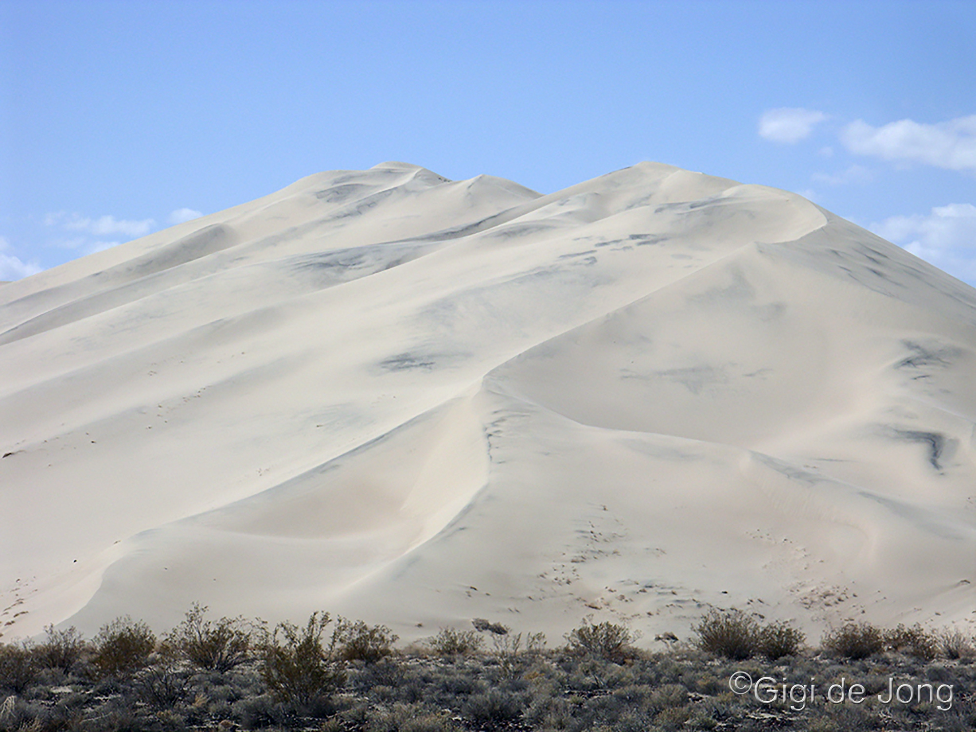
The singing sands. Eureka Dunes.
The Eureka Dunes are among the tallest sand dunes in North America, rising to about 680 feet off the valley floor. Situated in the northwest section of Death Valley National Park these dunes cover an area about 3 miles long and 1 mile wide and lie in an enclosed basin at 3,000 feet above-sea-level (ASL), the Eureka Valley. This valley and the dunes are more easily accessed from Bishop than from any southern route which crosses very rugged OHV terrain in the remote northern areas of the park.
Several unique (and protected) plant species are only found in this area. The Eureka Dune Grass (Swallenia alexandrae), the Eureka Evening Primrose (Oenothera californica eurekensis), and the Shining Locoweed (Astragalus lentiginosus micans) are endemic to the valley. The dunes are also known as the Singing Sand. The singing sound happens when the sand is completely dry and it avalanches down the steepest slope of the highest dune to create a sound like a bass note of a pipe organ.
Hiking to the top of the dunes is a popular activity in the cooler months of the year. It is not as easy as it looks. Slopes are steep and the sand will give way with each footfall on this loose surface. Daytime temperatures can be warm and nighttime temps may fall well below freezing.
jump back to map
Activities: Auto touring. OHV Driving. Dune climbing. Mountain biking. Photography. Camping.
Jump to related topics: #deathvalley #owensvalley
The Sierra Nevada. Mt Whitney. Palisade Glacier. The Great Basin.
The Sierra Nevada

Panoramic view of the Sierra Nevada escarpment.
The mighty Sierra Nevada range runs about 400 miles down the eastern side of California. It is part of an almost continuous chain of mountain ranges known as the American Cordillera that forms the ‘backbone’ of North America, Central America, South America, and Antarctica. The Sierra Nevada was once thought to be one of the youngest ranges on the planet and, although it is the youngest of the three big north American ranges (the Sierra Nevada, Rocky Mountains and Appalachian Mountains), it is now believed to be at least 40 million years old.
Mt. Whitney

Mt. Whitney with morning alpenglow.
Along this inland mountain spine, that is the Sierra Nevada, is the highest point in the contiguous United States. Mt. Whitney rises to 14,505 feet above sea level and many of its neighboring peaks are almost as high. They create a formidable and jagged crest along the steep eastern escarpment. The range covers more than half the entire length of California and rises well over 9,000 ft along most of its 400 miles, with over 120 peaks above 13,000 ft. It has created a water trap that has left the eastern, leeward side largely dry of precipitation. The moisture-laden airmasses that originate in the Pacific Ocean lift up the gentler gradient of the western side of the range and release their moisture, mostly in the form of snow, on the crest of the Sierra Nevada.
Palisade Glacier

Palisade Glacier below North Palisade. Photo: JeffreyMRoe at Wikimedia Commons
Huge accumulations of snow form on the peaks and in the canyons in the colder months every year – sometimes even in summer. During previous ice ages massive glaciers carved down the mountain and left innumerable lakes at all elevations as they retreated during the warmer climatic cycles. In today’s warmer climate, the annual snowmelt each year still yields a staggering quantity of water that is used to irrigate farmlands and supply cities throughout California. Glaciers still cling to high elevation cirques and couloirs, with one of the southern-most glaciers in north America, the Palisade Glacier, just above the town of Big Pine.
The Great Basin

Historical map of the Great Basin. Image: Wikimedia Commons
The Sierra Nevada forms most of the western boundary of the Great Basin in California. The Great Basin is a huge area of contiguous endorheic watersheds (closed basins where rivers and lakes have no outflow) that covers almost all of Nevada, much of Utah and Oregon, most of eastern California and Idaho, and a small strip of southeastern Wyoming. The topography of this enormous region is defined as basin and range, which is an alternating landscape of parallel mountain ranges and valleys. Together, the Sierra Nevada and the western edge of the Great Basin, are the defining features of the Eastern Sierra and have created the many unique characteristics and attractions of the region.
jump back to map
Activities: Trekking. Hiking. Fishing. Camping. Mountaineering. Rock climbing. Ice climbing. Trail running. Waterfall viewing. Fall color spotting. Backcountry and cross-country skiing. Photography. Mountain biking. Road cycling. Boating. Auto touring. OHV Driving.
Jump to related topics: #deathvalley #owensvalley #whitemountains
Alabama Hills

Mt. Whitney framed by the Mobius Arch in the Alabama Hills.
The Alabama Hills are as old as the starkly chiseled peaks of the nearby Sierra Nevada, but their smooth, rounded formations stand in surprising contrast to the craggy crest of the mountains that rise above. The beautiful, gently curved rocks and sculpted arches of the hills were formed while still underground ages ago. Chemical weathering and water percolating around the granite blocks carved them out as delicately as a master mason. The soil slowly eroded and exposed the graceful folds of rock where sand, wind, and water continue to refine and shape them.
The magnificent rock formations of the hills bordered by a vast open plain that rises dramatically and near‑vertically for almost 10,000 feet to the rugged, snow-capped mountains beyond has created a monumental landscape evocative of the old west. The region has been one of Hollywood’s favorite filming locations since the early 1900s.
One of the most striking natural arch formations is the Mobius Arch. It is perfectly situated and large enough to create a picturesque window through which to view Mt. Whitney (the tallest peak in the contiguous USA) in the backdrop of this stately range.
jump back to map
Jump to related topics: #sierranevada #owensvalley
Owens Valley and Owens (Dry) Lake

Gull over pond in Owens (Dry) Lake
The Owens Valley, also known by its traditional name, Payahǖǖnadǖ – place of flowing water, was once a wet, flood plain where water flowed into and filled a large lake at the southern end of the valley. Much of the water that is produced by the runoff from the Sierra snowpack is diverted to Southern California today, but water still flows down the Owens River as it meanders its way down the valley. Along the way it seeps into the aquifer and terminates in large, maintained ponds in what is now the dry lakebed of the Owens Lake. These newly restored wetlands are home to a remarkable variety of resident and migratory birds.
This valley is one of the many rift valleys of the Great Basin’s basin and range landscape. The valley floor averages about 4,000 feet above sea level, flanked by the Sierra Nevada to the west and the White and Inyo mountains to the east. Steep granite peaks rise dramatically on both sides with the crests reaching more than 14,000 feet. Geologists consider the Owens Valley one of the deepest valleys in the United States.
Spread out along the eastern side of the Sierra Nevada, the Owens Valley appears as an expanse where time has stood still. The vast landscape measuring 100 miles long and between 6 to 18 miles wide remains one of the least populated in the country. The towns are small, few and far between. The one major highway, US 395, dissects the valley north to south, threading through substantial plains of uncultivated lands that appear untainted by human interference.
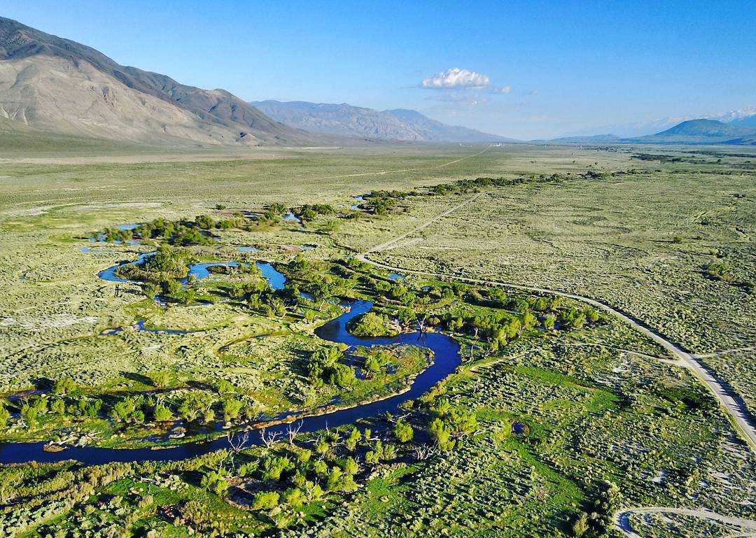
Owens River near Bishop. Photo: @lanedumm
The semi-arid and spectacular landscape of the Owens Valley is characterized as high desert. The rain shadow cast by the Sierra Nevada means the valley receives less than 6 inches of precipitation annually. However, this low figure belies the fertile capacity of the valley. Water courses down the mountain year-round to feed this valley that averages 92% sunny days a year. The geography and topography create conditions for each of the four seasons to develop and display their uniquely recognizable characteristics.
Much of the land in the Eastern Sierra is publicly owned by federal agencies such as the US Forest Service, National Park Service, and Bureau of Land Management. A significant portion of the Owens Valley is owned and managed by the Los Angeles Department of Water and Power and its vast, open lands are made available for public recreational uses. Together these landowners maintain millions of acres that cover deserts, plains, and mountains that are open and accessible to the public for extensive recreational opportunities.
jump back to map
Jump to related topics: #sierranevada #whitemountains
Owens River

Owens River with high spring flow.
The headwaters of the Owens River originate about 7-miles north of the town of Mammoth Lakes in an area that is now a protected wilderness. Located east of a relatively low elevation ridge of the Sierra Crest, precipitation from storms that arise in the Pacific fall or funnel into the high alpine meadows here. Seeps and springs create perennial wet meadows and these sustain one of the richest riparian habitats in the Eastern Sierra. The abundance of water overflows and is naturally channeled into the beginning of the Owens River. For about the first 6.5-miles of its origin, the Owens River and its two nearby tributaries, Glass and Deadman Creeks, hold the designation of Wild & Scenic River System.
This river, although relatively short at 183 miles, compared to the major rivers of the USA, has a long and legendary history. It flows through two of the major valleys of the southwestern Great Basin, Long Valley and the Owens Valley. It ends in the closed basin of the Owens Lake which is now largely dry. It is fed from its origin to its terminus by the enormous drainage of the Sierra Nevada.
Water is the essence of life and this river has sustained populations here for centuries. The region was inhabited by seminomadic Native Americans thousands of years ago. Evidence of their early hunter-gather culture has been documented in the traces of their sophisticated irrigation systems that were built to sustain small, efficient croplands.
The river has been the source of life and inspiration for explorers and settlers since its modern-day discovery in the early 1800s. Its importance is far more significant than many people know and understand. It is more than just a river that runs through an otherwise dry, semi-arid valley. It is the giver of life to millions. It is a significant contributor to sustaining the lives and lifestyles of millions of California residents today. Since the early 1900s much of the water from this revered river system has been redirected to supply the needs of Southern California. That’s a different story for another time.
The entire system is world renowned as a premier fishing destination; from the sweeping bends of the river along the valley floors, to the high-altitude streams that tumble down the mountainside, to the reservoirs that hold the constant flow of water. Over 95% of the region through which this river flows is protected and has remained sparsely populated. The Eastern Sierra is a mecca for outdoor recreation and the Owens River is central to its status.
_%E2%80%93_from_space_(ISS).jpg)
Impressive view of the entire Owens River system from the International Space Station. Photo: Wikimedia Commons
jump back to map
Jump to related topics: #sierranevada #whitemountains
The White and Inyo Mountains

View of White Mountains from Owens River
These gentle giants on the east side of the Owens Valley cover about 130 miles together from north to south. The narrow tip of the Whites rises to just over 13,000 feet at Boundary Peak like the prow of a ship sailing north. A little south of that and just northeast of Bishop is White Mountain Peak. At 14,252 feet, it is the highest peak in Mono County, the third highest peak in California after Mt. Whitney and Mt. Williamson, and the 14th most topographically prominent peak in the contiguous United States.
The White Mountain range is the highest range that is completely within the Great Basin of north America. It is also entirely inside the Inyo National Forest boundary with more than half of the range designated as wilderness. The planet’s oldest living things live here. Over 5,000 years of living history is preserved in the trees, the Ancient Bristlecone Pines, that eke out a rare existence high on the barren mountaintops above the Owens Valley.
The southern end of this range expands to about 20 miles wide where it meets its counterpart, the Inyo Mountains. The highest peak in the Inyo range is Waucoba Mountain at 11,128 feet above sea level. From there the range narrows and descends to a point on the high desert floor at 4,800 feet a few miles southeast of the Owens Lake.
Together the White and Inyo ranges form one giant fault block separated by a narrow gap through which State Route 168 runs. This wonderful, winding mountain road connects the Owens Valley with Deep Springs valley (a geological marvel itself) and beyond to Fish Lake valley in Nevada. It also provides access to a variety of mountain activities and viewpoints to the valleys below and the stars above.
jump back to map
Jump to related topics: #sierranevada #bristlecones
Ancient Bristlecone Pine Forest

Great Basin Bristlecone Pines live for millennia high up in the White Mountains.
The planet’s oldest living things live here, high up on the desolate, windswept peaks of the White Mountains. The Great Basin Bristlecone pine trees live for thousands of years and the oldest of these gnarled, weather-beaten, and resilient old trees is confirmed to be almost 5,000 years old. It has been named Methuselah and its location is kept secret by the guardians of this forest.
The trees were discovered by Edmund Schulman, a researcher in the field of dendrochronology (the science of tree ring dating) in 1953. His findings and research greatly influenced the study of dendrochronology, and the bristlecone chronologies raised questions relating to the widely respected field of radiocarbon (C-14) dating methods. The C-14 process was subsequently recalibrated using data collected from the study of these trees. It is said that these trees rewrote history.
The Ancient Bristlecone Pine Forest is a protected area under the auspices of the US Forest Service. This healthy and growing forest is located high in the White Mountains, between 9,000 and 11,000 feet above sea level. Many of the individual trees that live in this forest are over 4,000 years old.
The grove where Methuselah lives is easily accessed by road from SR 168 along White Mountain Rd to the Schulman Grove Visitor Center. The center is open annually from about mid-May through November, weather permitting. Trails that weave through the forest take visitors on a journey of discovery. The views out across the Owens Valley to the west and the Great Basin of Nevada to the east offer a perspective that cannot be seen anywhere else.
jump back to map
Jump to related topics: #sierranevada #whitemountains
Buttermilk Country and the Tungsten Hills

A multitude of rocky formations make up the hills of Buttermilk Country.
The hills and vales that lie west of the town of Bishop and below the impressive Sierra Nevada beyond are another intriguing geological area. The huge block that is the Sierra Nevada rises dramatically and steeply here with no real foothills to mark its rise. The Tungsten Hills and Buttermilk Country appear to be foothills, but they are older than the massive mountain nearby and somewhat different from each other.
The many forces that shaped this region are wonderfully evident all up and down the Eastern Sierra. In this mostly dry and exposed landscape that is tilted and warped by tectonic activity, and cut and scraped by glacial activity, the visible rocks and rock structures represent many different eons of geologic history. In some places ancient formations extend above and on top of younger layers. In other places rocks that are entirely different from their surroundings are disconnected from their origins.
In previous ice ages, the last being less than 10,000 years ago, glaciers inched their steady way down the mountain cutting deep canyons and pushing tons of matter out ahead and alongside of them. The crushing weight of the ice reduced much of the rock to rubble and sand to create channels with sidewalls known as moraines. Monster boulders that were plucked from the mountain were pushed out ahead and, as the glaciers retreated during the warm periods, these boulders known as glacial erratics remained far removed from their source.
The Buttermilk Country is clear evidence of these all these forces of nature. Huge boulders lie scattered about on this diverse, hilly terrain. It is an impressive and inspiring landscape and it is protected for generations to come. Climbers frequent the area for the near perfect bouldering conditions on some of the largest erratics anywhere, with individual boulders more than 40 feet tall.
Adjacent to and north of Buttermilk Country, directly west of Bishop, are the Tungsten Hills. They form the northern end of a larger feature known as the Coyote Warp that lies between Bishop and Buttermilk Country and the Sierra Nevada beyond. The Tungsten Hills are distinctly different from all the surrounding features due to their mineral composition. The bedrock of quartz monzonite extends well below and beyond these exposed hills, but what makes them unique within this area is the presence of Tungsten. This naturally occurring mineral was extensively mined in this area in the early 1900s and old mine sites and mining debris remain scattered around these hills.
Tungsten, which has the chemical symbol W (derived from its earlier Germanic name Wolfram) and the atomic number 74, is considered necessary to life. As a free element (pure or not combined with another element) it is remarkably robust. Of all the elements discovered it has the highest melting point (6,192 °F) and the highest boiling point (10,710 °F) as well as the highest tensile strength. It is still widely used in alloys for applications such as: rocketry, armaments, NASCAR, lightbulbs, and even fishing lures. Most of the world’s Tungsten comes from China today.
Together these two hill sets create a vast area for a variety of recreation and extensive exploration. All within easy access from nearby Bishop. It is wonderful place for a late-night astronomy experience. Daytime rockhounding in the Tungstens is popular too where ore bearing rocks contains red garnets and quartz crystals can be found.
jump back to map
Activities: Hiking. Bouldering. Rock climbing. Trail running. Rockhounding. Camping. Mountain biking. Bird watching. Dirt biking. OHV Driving. Night Sky viewing. Photography.
Jump to related topics: #sierranevada #nightsky
The Night Sky

Ancient Bristlecone Pine and ancient stars. Photo: Tony Rowell
The stars in our sky everywhere hold clues to our planet’s history. But in most places in the world, very few, if any, stars can be seen anymore. This is due primarily to light pollution from cities and densely populated regions on our earth. Experts believe that 80% of North Americans cannot see the Milky Way from where they live. One-third of humanity can no longer see this starry spectacle and countless adults and children have never, ever seen it.
The Eastern Sierra still has incredibly dark, clear skies. The Milky Way is as obvious here today as it was when Galileo first focused his rudimentary telescope at this phenomenon in 1610 and discovered that it was made up of stars. The night sky here is a magnificent sight to behold, especially on a moonless night during summer when the Milky Way arcs high overhead. Visitors to our area tell us that they are awestruck by the abundance of stars and clarity of the Milky Way on a new moon night.
The night sky has captured human imagination from time immemorial. Scientists, artists, philosophers, photographers, lovers, and people of all cultures have gazed up at the sky in wonder. Here in the Owens Valley on the east side of the Sierra Nevada there are many easily accessible places where night sky viewing is exceptional.
We believe everyone should have the opportunity to see, at least once in a lifetime, the amazing spectacle of the Milky Way and an intensely sparkling, starry night sky. Take some time to study our night sky guide and learn where all best spots are for a stellar experience. One of the most amazing places for star-studded entertainment is high up on the White Mountains, near the Ancient Bristlecones. A late summer night up here offers a view, not just of the valley below and the stars above, but a window to our past and our future.
jump back to map
Activities: Astronomy. Auto touring. Camping. Photography.
Jump to related topics: #bristlecones #whitemountains
The Long Valley Caldera, the Tablelands, the Owens River Gorge, and the Crowley Columns

Looking down on the Owens River from the top of the chalk bluff. @davidvonnegutchambers
A feature of the Eastern Sierra that attracts visitors to the region is the presence of natural hot springs scattered across the landscape. Super-heated water bubbles up from fissures in mountain canyons, wide-open valley floors, and below stream beds. These are all active evidence of the volcanic activity that shaped this region.
At the northern end of the Owens Valley is an impressive scarp that rises vertically up over 300 feet. It was the product of a massive volcanic eruption about 760,000 years ago. In the area that is now the Long Valley Caldera, about 25 miles northwest of Bishop, a huge magma chamber blew through the earth’s thin crust releasing very hot ash. This pyroclastic flow surged outward and downward, creating a huge layer of glowing, hot ash that subsequently cooled and hardened into a soft rock that we now call Bishop Tuff.
As the Owens River continued to flow it cut through the tuff and created the deep, steep-sided Owens River Gorge that we see today. The gorge and the many smaller canyons and washes that were cut by seasonal water flows over the edge of the escarpment are hugely popular rock-climbing areas. The face of this escarpment, called Chalk Bluff for its fine texture and pinkish-white color, is an outstanding feature of the topography surrounding Bishop.
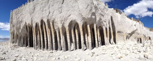
A cavern of columns at Crowley Lake.
At the same time as the initial explosion deposited the ash that formed the Bishop Tuff, the roof of the magma chamber collapsed and dropped almost 2-miles to form an oval-shaped depression, a caldera. That huge eruption also sent wind-blown ash across much of the western USA. Subsequent eruptions were smaller and confined to the caldera and slowly lifted the dome of the depression that is now the Long Valley Caldera.
This naturally enclosed area, although not a closed basin, created an opportunity for water storage and the Long Valley dam, built in 1941, resulted in the creation of Crowley Lake. An exceptional set of circumstances due to this artificially created reservoir caused a curious set of rock features to be exposed by the powerful waves of the lake pummeling the softer rock along its shoreline. During a recent, serious, years-long drought, from 2012-2017, the lake level receded revealing a formation of rock columns along the lakeshore.
Researchers have only recently begun to study this unique natural phenomenon. According to a recent study, researchers from UC Berkeley have determined, “that the columns were created by cold water percolating down into — and steam rising up out of — hot volcanic ash spewed by a cataclysmic explosion 760,000 years ago.” As the lake level rises and recedes it continues to erode the softer rock around the harder columns and dig deeper into this underground labyrinth.
jump back to map
Activities: Auto touring. Dirt biking. Hiking. Rock Climbing. Fishing. Boating. Photography.
Jump to related topics: #craters #monolake #owensriver
Mono-Inyo Craters System

Mono Inyo Craters aerial image by NASA, Annotated using Inkscape. Wikimedia Commmons.
The volcanic history of the Eastern Sierra has left a chain of craters, domes, and lava flows that stretches 25-miles from just south of Mammoth Mountain (an extinct lava-dome volcano) to the islands in Mono Lake. This line of features is clearly seen from the air and on satellite images. Up close, each of the features of this volcanic system are somewhat different from each other and range in age from 250,000 years old to as young as 250 years.
The first activity that is associated with this chain began about 400,000 years ago, more than 350,000 years after the Long Valley eruption. This was a precursor to the blasts that formed the features of this chain we see today. Mammoth Mountain is the oldest feature in this chain. It was formed some 200,000 to 50,000 years ago through a series of slow steam and viscous lava eruptions that layered it to create the huge lava dome that, today, is home to one of California’s premier ski resorts.
The volcanic activity moved north into the Mono Basin and from about 40,000 to as recent as 600 years ago erupted to the form the Mono Craters. These rocky, gray, cinder cones, which are largely free of vegetation, are very obvious to the east of US Highway 395 between June Lake and Lee Vining.
Toward the end of that period, a series of explosions formed the Inyo Craters which created a different set of features that include deep craters and massive black obsidian domes. Ash from all these explosions forms the bed on which the town of Mammoth Lakes is built.
The most recent feature in this chain is Paoha island within Mono Lake. It is formed mainly of lakebed sediments that settled on top when an intrusion of magma rose from below the lakebed. A series of volcanic explosions that began in the early 1700s and ended as recently as 1850 created the island. The neighboring smaller island, Negit Island, is almost 1,500 years older. In times when the lake water has receded significantly, these two islands form a peninsula connected to the mainland.
A less obvious, but well-formed circular dome on the northern shore of the lake, Black Point, is a flattened volcanic dome that formed below the surface of Mono Lake during the last glacial period, about 13,000 years ago, when the lake was much deeper. At the southern end of this chain are the two Red Cones, which are about 5,000 years old. They are fairly well concealed by the surrounding forest and only accessible by hiking south along the Pacific Crest Trail (PCT) from Devils Postpile National Monument or hiking southwest from the Mammoth Lakes to the PCT where it runs between these two cones.
jump back to map

Mono Craters seen from US 395. Photo: Daniel Mayer
Jump to related topics: #tablelands #monolake #devilspostpile
Devils Postpile

Devils Postpile National Monument. Photo: Frank Kovalchek – Wikimedia commons
About 100,000 years ago, within the volcanic period that created the Mono-Inyo Craters System and nearby to it, a lava vent began spewing hot, basaltic lava. In an area known today as Reds Meadow Valley, just west of Mammoth Mountain, this iron- and magnesium-rich molten rock flowed down the valley until it reached a natural dam. The dam, most likely a glacial moraine produced by a receding glacier from a previous ice age, trapped the liquid lava and created a huge lava lake, at least 400 feet deep in some places. Slowly and over time, the molten rock cooled and hardened and, as it did so, it contracted and began to crack.
As often happens in nature, but is seldom seen on such a dramatic scale, the cracks appeared in uniform formations. Colossal columns of rock took on geometric shapes to create near symmetrical hexagons and polygons. For millennia much of this formation was underground, but erosion eventually exposed major portions of this columnar basalt. Repeated cycles of freezing and thawing broke columns apart. Earthquakes shook and knocked columns and pieces down. A river roared down this valley and washed pieces away. But the greatest forces that excavated, scoured, and polished these beautifully formed pillars were glaciers from subsequent ice ages.
Today the formation is protected within the Devils Postpile National Monument. The towering columns of this massive rock pile are easily accessed by a short walk from the Reds Meadow visitor center. The trail skirts the base of the buttress and climbs up a slightly irregular stairway of polished stone that appears to be inlaid into an alpine forest. The river still courses through this valley and falls over rocky walls into large clear pools.
jump back to map
Mono Lake
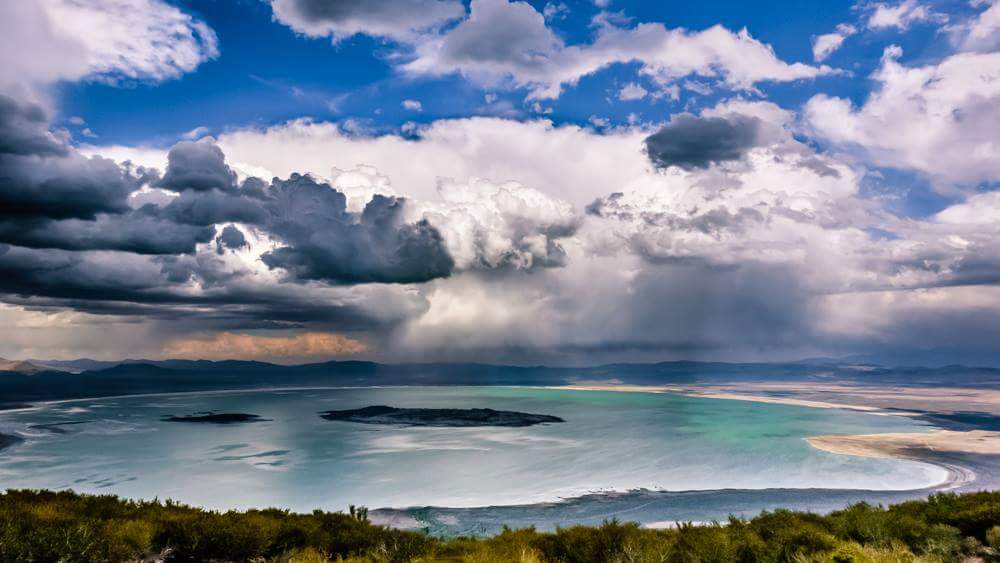
Storm cloulds over Mono Lake
Mono Lake is a large, shallow saline soda lake situated in Mono County, California. The county was named after the lake. The lake was named for the Mono People, a Native American Paiute tribe that historically lived in the area. It is said the name derived from the name given to them by their western neighbors, the Yokuts, who called them monachie, meaning “fly people.” The abundant fly larvae found at the lake was their staple food and article of trade. The words monachie and monoache were shortened to mona and mono – the latter became the name of people and the lake. The name is pronounced Moh-No.
The lake in its present form was probably created by the Long Valley eruption some 760,000 years ago, but it is thought that it may also be a remnant of a larger, older lake that covered much of Nevada and Utah and is 1‑million years old now, one of the oldest lakes in north America. This desert lake lies in a closed basin, which allows no outflow of water, resulting in high levels of salt in the water. Even so it has an unusually productive ecosystem revolving around the brine shrimp that thrive in its alkaline waters.
Although fish do not survive in this water the lake is home to a species of brine shrimp, Artemia monica, found nowhere else the world. They are dormant in winter, but come spring up to 6‑trillion brine shrimp surface and trillions more alkali flies hatch – the larvae of which formed the basis of the diet of the early Mono people. These have also long been a delicacy for millions of migratory birds, like the California Gull, which is famous for its tactic of running through a raft of flies and scooping them up like winged, snapping bulldozers. More than 80 species of migratory birds’ flock and breed on these shores.
Mono Lake is geographically, geologically, and historically unique and wonderful. It is also surreal and ethereal. Of its many fascinating features, none are stranger than the Tufa towers that appear to rise out of the water in unearthly formations. These tufa towers are calcium carbonate deposits which form, under the lake’s surface, as freshwater springs bubble up into this excessively salty and alkaline lake.
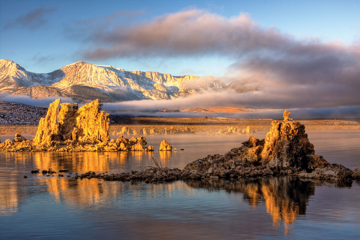
Tufa towers in Mono Lake. Image courtesy of Mono County tourism.
These towers were only exposed recently, geologically speaking, between 80-50 years ago when the lake lost almost half its depth due to the creation of an aqueduct that diverts water to Los Angeles and southern California, some 300 miles south. As it did the sensitive ecosystems began to crumble and the water salinity increased dramatically.
Since 1978 the Mono Lake Committee has fought for the protection and preservation of the lake and its fragile ecosystem. The Mono Lake Tufa State Natural Reserve was subsequently established to protect the tufa, wetlands, and habitat for the millions of birds that rest and feed here annually. The Mono Basin Scenic Area Visitor Center is located ½-mile north of the town of Lee Vining. It is open seasonally in the warmer months and houses wonderful interpretive displays that shed light on the past, present, and future of this natural wonder.
jump back to map
Activities: Hiking. Bird watching. Kayaking. Fall color spotting. Photography.
Jump to related topics: #craters #tablelands
Yosemite National Park
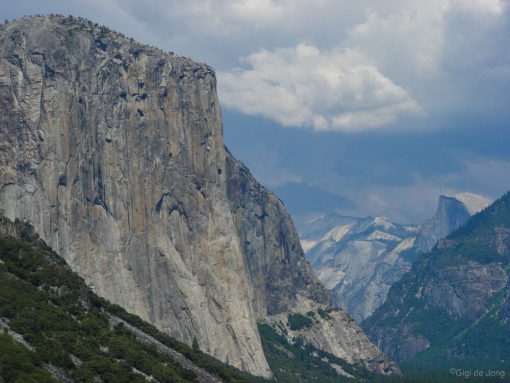
Storm clouds roll in over El Capitan and Half Dome in Yosemite National Park
At the northern end of our Eastern Sierra, just outside of Lee Vining, near Mono Lake is a road leading to a place that is often described with terms like: nirvana, Eden, paradise, and heaven. It is Yosemite National Park. The road is closed in winter as snow lies deep and heavy on this rugged landscape. When the snow is cleared and the narrow, winding road up to Tioga Pass is opened, it opens up a world of wilderness exploration and adventure into our valued public lands and the history of this treasure.
On June 30, 1864 President Abraham Lincoln signed a bill granting Yosemite Valley and the Mariposa Grove of giant sequoias to the State of California. The bill stated, “for public use, resort and recreation,” and the two tracts “shall be inalienable for all time”. The federal government had, for the first time in history, set scenic lands aside purely as a means to protect them and allow for their enjoyment by all.
Twenty-six years later, on October 1, 1890, an Act of Congress designated Yosemite National Park as the third national park in the United States, after Yellowstone (1872) and Sequoia (1890).
Yosemite is best known for the towering granite cliffs, tall waterfalls, clear streams, giant trees and abundant fauna and flora. Most visitors spend their time within the seven square miles of the awe-inspiring Yosemite Valley, but the park covers almost 1,200 square miles, of which almost 95% of it is wilderness.
Ranging in elevation from 2,127 to 13,114 feet the park contains five major vegetation zones: chaparral/oak woodland, lower montane forest, upper montane forest, subalpine zone, and alpine. Of the 7,000 native plant species in California, more than 20% are found in the park. It is considered one the largest and least fragmented habitat blocks in the Sierra Nevada.
jump back to map
Jump to related topics: #craters #sierranevada
Choose Your Own Adventure
Planning is key. We have tons of great information on our website. Follow the links, study the maps, review the stories, and call us with any questions you may have. We have local experience and knowledgeable staff on hand to discuss your dreams, learn your goals, and help you create the best experience possible.
We can help you Choose Your Own Adventure.
It all starts with research and planning.
Remember that whenever you visit the Eastern Sierra be prepared. Climate in our region is marvelously unpredictable so bring layers of clothing, always carry plenty of water and extra food when trekking in our big backyard, and wear a hat and sunscreen most days of the year. Always tell someone where you are going, when you expect to be back, and follow up when your adventure is complete.
We love our big backyard, which has been much like this for eons. We encourage everyone to enjoy its wonderful, wild beauty and to take the pledge to Protect. Preserve. Participate. Perpetuate.