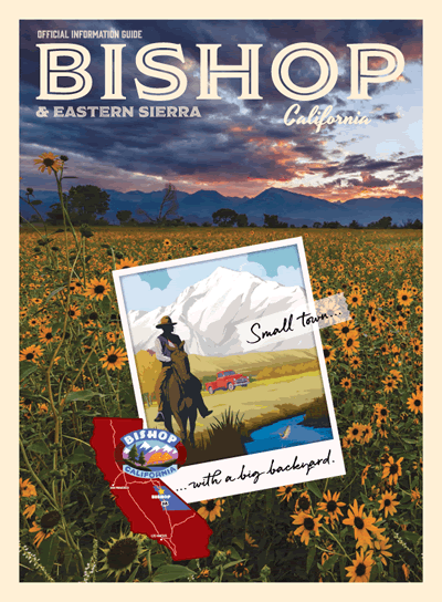
Road Trip US Highway 395 to Bishop – the small town with the big backyard
The Eastern Sierra is often referred to as “the other side of California,” and these places might also make it “the weird side of California.” Pick your path along US Highway 395, from Los Angeles to Bishop and little beyond, where you will see some of the most curious, grotesque, mysterious and awe-inspiring features of nature and feats of humankind.
The story of US Highway 395
Just beyond Bishop the road begins to climb alongside the Sierra Nevada, with a steep rise over Sherwin summit. Beyond Mono Lake it reaches its highest point at 8,138 feet in altitude at Conway Summit in Mono County. The road passes four summits on its journey northward then at Topaz Lake it dips into Nevada for 87 miles. After one final summit pass, Simee Dimeh Summit, the road exits the mountains and follows the receding escarpment of the sierra and into the urban areas of Carson City, Reno and Sparks.
Returning to California US Highway 395 runs through Sierra, Lassen and Modoc Counties, serving the towns of Susanville, Ravendale, Termo, Madeline and Likely. At New Pine Creek, CA alongside the eastern shore of Goose Lake. Here it enters Oregon and continues its journey north for another 673 miles to the Canadian border. The entire length of US Highway 395 is 1,305 miles.
Hotspot map of US-395 Road Trip
Hover over a hotspot icon to see an image and heading, then click to jump to read more about that feature.
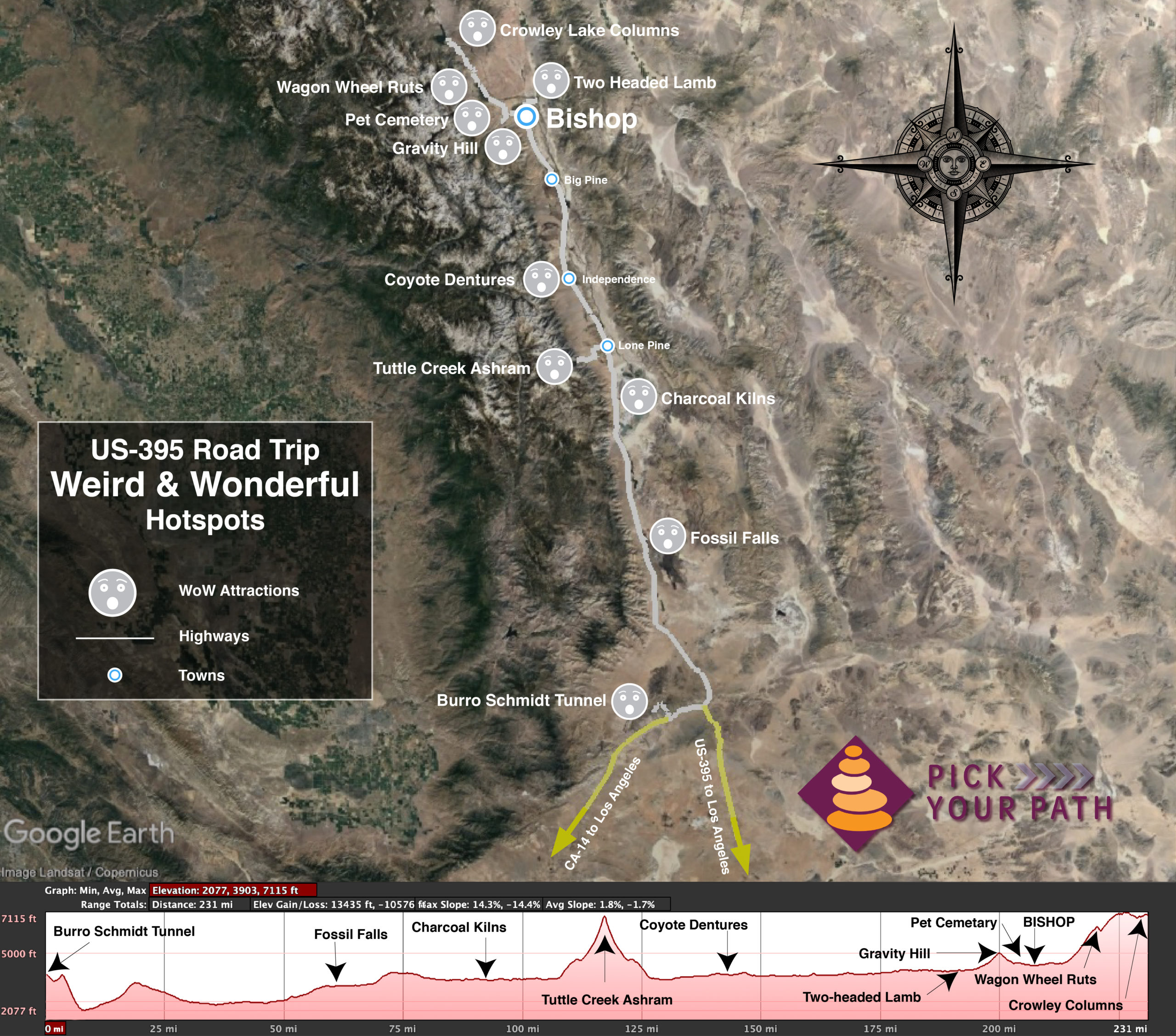
Burro Schmidt Tunnel
Fossil Falls
Charcoal Kilns
Tuttle Creek Ashram
Coyote Teeth Dentures
Two-headed lamb
Gravity Hill
Pet Cemetery
Wagon Wheel Ruts
Crowley Columns

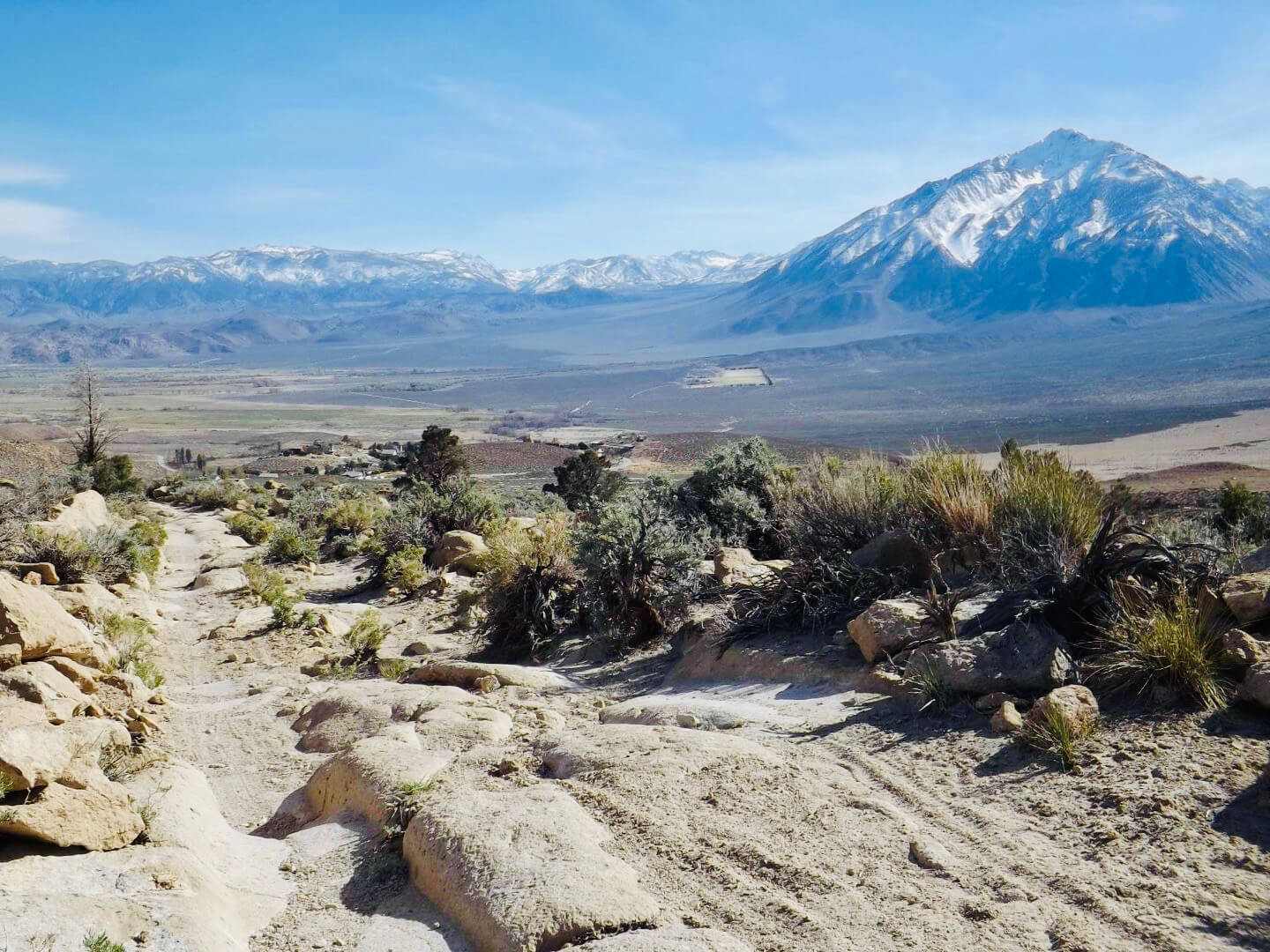
Pick Your Path
We begin our road trip from the northern edge of the Los Angeles basin.
From the start of US-395 in Hesperia, it’s a mere 88 miles to our first weird attraction. From the western side of the basin where I-5 meets CA-14, in the San Fernando pass, it’s only 109 miles to the first stop on our wonderful journey. CA‑14 soon meets up with US-395, and it is here in the vast expanse of the Mojave Desert where your journey of discovery really begins.
Some of these attractions require 4-wheel drive and high-clearance vehicles and good OHV driving skills. Some also include a bit of hiking to access the feature. Others have easy access on paved roads, with services at or nearby the attraction, such as: food, restrooms, gas, lodging, and visitor information where you can learn more details about the feature.
Study the map above and choose the ones that really fascinate you and your group. Click on a hotspot icon to jump down to see details and an image of each of these wondrous features. Next make sure you have the right vehicle, gear, and enough time for your intended destinations. Then pick your path!
Best of all—next time you can pick a completely different path and explore more.
Burro Schmidt Tunnel
Location: 163 miles south of Bishop off the Redrock Randsburg Rd near Garlock.
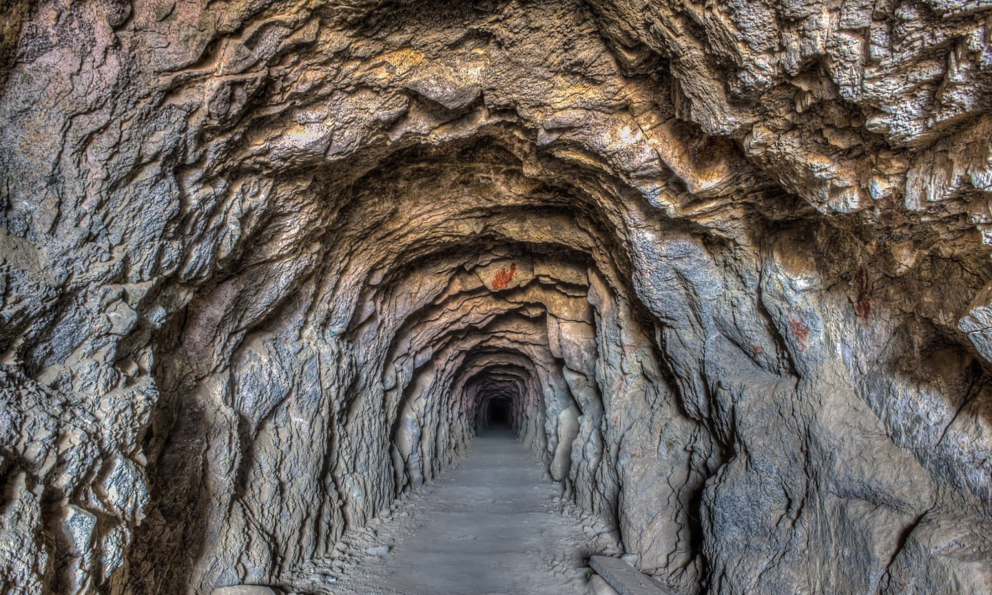
A ‘short cut’ to … nowhere?
One man with two donkeys, a few hand tools, a wheelbarrow, and some explosives, spent over 33 years singlehandedly digging a tunnel almost a half-mile long in the solid rock of Copper Mountain in the remote Mojave Desert of California. During his lifetime William “Burro” Schmidt would never fully explain his tunnel excavation project, except to say that is was a “short cut.”
He had moved to California from Rhode Island for health reasons and staked a mining claim in the Mojave Desert’s El Paso range. At that time transporting the ore from his claim to the smelter in Mojave was along a perilous mountain trail. Schmidt is reputed to have said that he would never haul his ore to the Mojave smelter “down that back trail” using his two burros.
He became obsessed with digging and completing a tunnel and disregarded mining entirely, even though he discovered potentially rich veins of gold, silver, copper, and iron during the big dig. The tunnel, however, emerged on a high ridge well above the desert floor below and is now called the “short cut to nowhere.” Schmidt never transported a single ounce of ore through the tunnel.
Today the tunnel remains intact. Although Schmidt had no formal training it is obvious that he was a quick learner and the skills he picked up from digging, often through mishap and injury to himself, produced a feat of incredible and accurate engineering.
The tunnel, Schmidt’s cabin, and surrounding land are now under the auspices of the Bureau of Land Management (BLM) and can be easily accessed via road. Take a walk through the tunnel and see the commanding view of Saltdale on the other side.
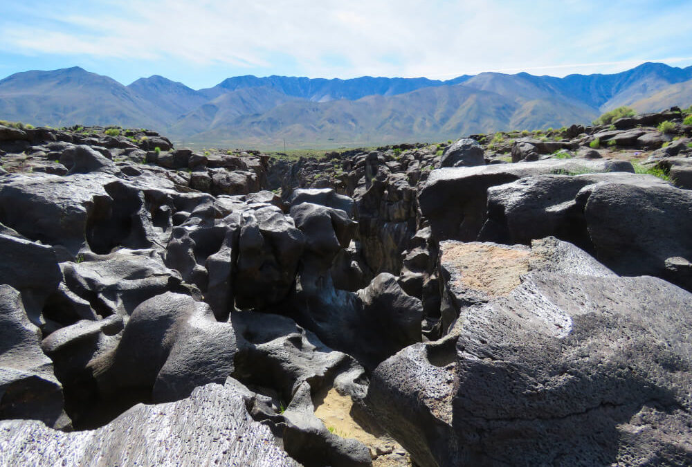
Fossil Falls
Location: 104 miles south of Bishop near Little Lake
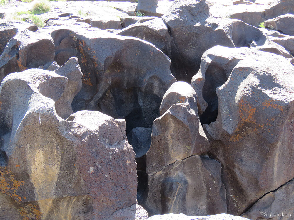
The smooth, rounded shapes of volcanic rock shaped by eons of running water.
This geological wonder is a magnificent example of the forces of nature that shape our world. Technically it’s not a fossil and water no longer falls here in any abundance. This surreal canyon of basaltic black lava rock is now a natural work of art beautifully sculpted by eons of rushing water from a prehistoric age.
The chasm is almost unnoticeable in the flat lands of the valley floor until you get quite near to it, then it unfurls below you in folds of glossy, black rock that is both beautiful and strange. The rock is smooth and shiny and distinctly different from the surrounding landscape. It is stark evidence of a time when the valley was wetter, and of the inevitability of change.
Early inhabitants lived along the banks of this ancient river, where artifacts and rock art indicate a viable hunter-gatherer culture existed here some 10,000 to 20,000 years ago.
A trip to Fossil Falls is less than a mile off Highway 395 where a few minutes, a couple of hours, or an overnight camping trip will expand your view and understanding of this remarkable valley.
Charcoal Kilns
Location: 73 miles south of Bishop adjacent to the Owens Dry Lake
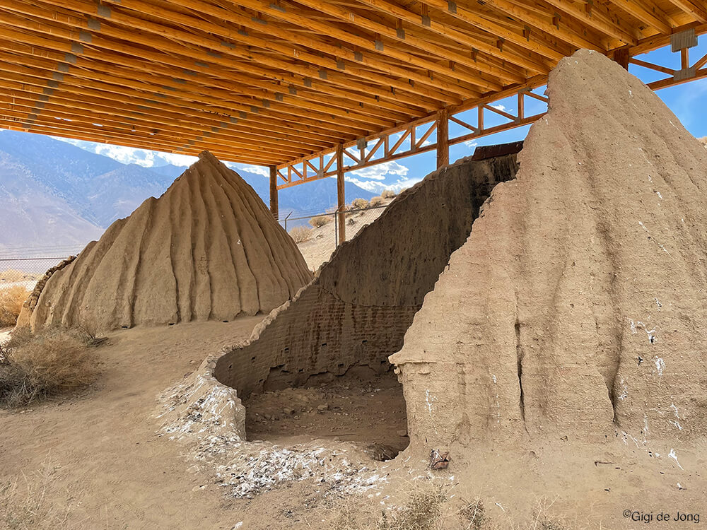
Ruins of old charcoal kilns near Lone Pine.
This is another testament to human ingenuity and not as outlandish as some of the others on this list, but nonetheless quite outstanding.
High in the Inyo Mountains of the Eastern Sierra is Cerro Gordo, once a prosperous silver and lead mine. In just 10-years from the 1860s to 1870s about $20 million dollars-worth of silver and lead bullion was shipped from Cerro Gordo. It holds the distinction of being the most prosperous mine for those metals in California history.
Soon into its development as a booming mining operation, lumber in the nearby mountains was denuded and a quality fuel for the smelters was urgently needed from elsewhere. Like with so many mines of the day, charcoal kilns were used to ‘cook’ wood into charcoal for use in smelting and purifying precious metals and produce ingots.
The logistics of Cerro Gordo were tricky, but not insurmountable. Charcoal kilns were built along the shores of the lake and nearby Cottonwood creek where, at that time, wood and water were abundant. Good fireclay was present in the region too and, whereas most kilns of the day were built using bricks or stone, these were built from clay bricks and covered with plaster.
Cottonwood trees were cut, ‘cooked’, and transported across the lake on steamboats to the town of Keeler and thereafter hauled up the mountain by horses and mules to the smelters at Cerro Gordo. The valuable bullion was brought back down the mountain, ferried across the lake on the same steamboats, the “Bessie Brady” and “Mollie Stevens,” to Cartago where it was shipped onward to Los Angeles.
Where Highway 395 runs west of the old shoreline of the now dry Owens Lake, is a dirt road leading to the historical landmark that is the Cottonwood Charcoal Kilns. These 25-foot wide structures are an eerie reminder of an economic and environmental era that is now vastly different in the region.
Tuttle Creek Ashram
Location: 63 miles south of Bishop, near Whitney Portal (and 1.6 miles of rough 4×4 track and a fairly strenuous 3.5 mile roundtrip hike up into Tuttle Creek Canyon)

Ascending to the Ashram requires a bit of effort.
The mountains have long been considered spiritual destinations for people seeking solitude and enlightenment. To climb lofty peaks and be closer to the heavens or view the world from an ‘otherworldly’ perspective is a goal to which many have ascended.
Buddhist monasteries perched high in the mountains of China and temples that dot the foothills and ice-clad peaks of the Himalayas are numerous. For pilgrims seeking something here in the USA, the Sierra Nevada holds a one such special, spiritual place.
The Tuttle Creek Ashram is tucked high into the mountains above Lone Pine at 8,000 feet above sea level. In 1930 a couple, Franklin Wolff and his wife Sherifa – both philosophers, mystics and writers – began construction on the 2,000 square foot stone building designed in the shape of a balanced cross to symbolize the principles of equilibrium.
In the ensuing years the ashram has been vandalized, all-but abandoned, almost dynamited to rubble, and finally evaluated as historically significant and nominated for recognition in the National Register of Historic Places. It is now under the jurisdiction of the US Forest Service.
The location of the ashram was specifically chosen to be near the highest point in the contiguous USA, Mt. Whitney, as the couple believed the spiritual point of a country to be near its highest elevation.
Coyote Teeth Dentures
Location: 42 miles south of Bishop at the Eastern California Museum in Independence

That’s a serious bite! Photo: Eastern California Museum
What would you do if you were living a meager life in the early 1900s in a remote mountain community and had lost all your teeth? Perhaps you’d count your pennies and go see a local dentist. Perhaps the closest dentist is in a town far away and you can’t afford the time or expense.
A gruesome artifact, now on display in the Eastern California Museum in Independence, seems to tell the story of a man who, in about 1930, found himself in this predicament. What he did is not just grotesque, but rather ironic as well.
He fashioned a set of dentures from the teeth of a dead coyote!
He made the now famous Coyote Dentures by melting celluloid from toothbrush handles, molding the mixture to the shape of his gums, then pressing the yellowed coyote teeth into the cast.
Perhaps he wasn’t poor just miserly, but he definitely was macabre.
Two-Headed Lamb
Location: 6 miles north of Bishop on US Highway 6 at Laws Railroad Museum
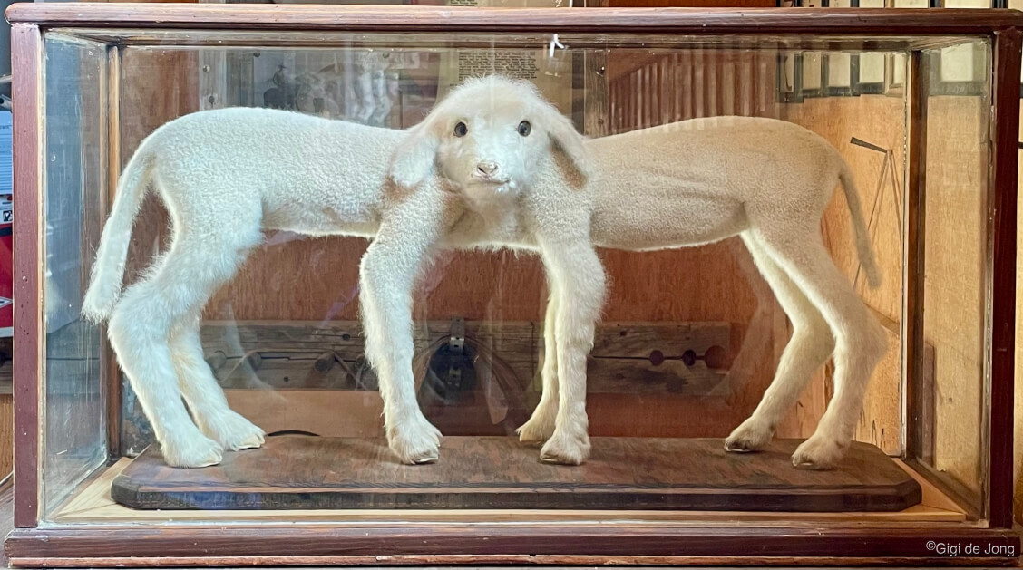
Siamese twin lambs born circa 1940 now on display at Laws Railroad Museum.
The birth of Siamese twins to farm animals is not exceptionally rare, but it is always rather shocking.
Sometime around 1940, on a local farm northwest of Bishop, Siamese twin lambs were born. The conjoined twins were born joined at the neck and, although they are known as “the two-headed lamb” or “the two-faced lamb,” they each actually have a complete body too.
According to the daughter of Clifford Jones, who lived on the farm since a child, the lambs lived for a short time and after their death he stuffed the lambs for posterity. They are now on display at Laws Railroad Museum along with a multitude of other intriguing artifacts of the weird and wild west.
Gravity Hill
Location: 7 miles west of Bishop on E. Bishop Creek Rd, just off State Route 168 (E. Line St.)
A stretch of road where gravity doesn’t seem to work.
There is a particular spot on a quiet, remote road just west of Bishop where you will not experience the effect of gravity quite like you will anywhere else. In fact it should be called “Un-Gravity Hill.”
At a precise point in the road where it appears to be heading uphill, you can stop your car, place it in neutral, and it will slowly begin to move forward and upward. At first your vehicle will slowly creep forward, then it will gain speed going uphill! Then, as gravity gets a grip on this crazy situation, the car will slow and finally come to a stop. You might get to the crest of the hill or you might not. It all depends on how strong the force is that day.
It is an optical illusion of the freakiest kind. How fast and far you travel will depend on your starting point and the weight and rolling resistance of your vehicle.
May the force be with you!
Pet Cemetery
Location: 7 miles west of Bishop on Tungsten City Rd, just off Highway 395

Where beloved spirits run free for eternity.
This is a wildly wonderful place where hundreds of beloved pets are buried. Here it is just possible that their eternal spirits are running along the trails, jumping in the streams, or stalking through the bushes that they so loved when they lived here.
The area is hauntingly beautiful and the feeling of love is palpable and a sensation of enduring loyalty is ubiquitous. The love and gratitude displayed by the care with which this area is used and maintained makes it clear that these well-loved animals are deeply missed. Many gravesites show evidence of frequent visitation. Fresh cut flowers are a strange and colorful sight in this otherwise dusky desert. There are beautifully carved crosses and elaborate gravestones with sweet epitaphs and heartfelt remembrances. The sites are adorned with toys, collars, leads, and bowls so an energetic spirit can play exuberantly and quench its thirst.
Tread lightly on the paths that run across the grounds where our best friends are laid to rest. Perhaps here they now run unencumbered for eternity. Look for them. They are there.
Wagon Wheel Ruts Carved in Rock
Location: 19 miles north of Bishop on the Old Sherwin Grade, near Swall Meadows
A trip up or down this old wagon road took all day 150 years ago.
Mining was big business in California 100 years ago and here in the Eastern Sierra it was a tough business. This landscape with its craggy crests and rocky ridges presented monumental challenges for transporting goods and lumber between the settlements, mines, and mills. One of the biggest transportation challenges in the region was going up or down the Sherwin grade between the Owens Valley and Long Valley.
James Sherwin for whom this ridge is named was an industrious man. He was born in Cincinnati, Ohio and moved to the valley around 1866. In 1870 he built the first of a few of roads up this 3,000-foot-high escarpment primarily to move huge shipments of lumber from the mill at Lower Rock Creek to Round Valley. The only way to move these loads was in massive wagons weighing many tons.
Those hardy pack animals, the magnificent mule, which are still used today in the rugged backcountry, were teamed up in trains of 20 mules to haul huge wagonloads up and down the mountains.
The proof of their labor and the intrepid packers who drove the teams along the trails has been permanently etched into the rock of the Sherwin Plateau north of Bishop. Deep ruts were slowly carved into this soft rock, known as Bishop Tuff. The relics of this old road now appear incongruous with the wild surroundings of the mountain slopes and the modern US highway 395 that weaves its way up this steep escarpment.
There are several good examples of these original roads still discernible on the hillside. If you stand in the remnants of these old ruts and listen quietly, you might hear the braying of the mules and creaking of the wheels as if carried on the wind from a century ago.
Crowley Lake Columns
Location: 30 miles north of Bishop, on the shores of Crowley Lake
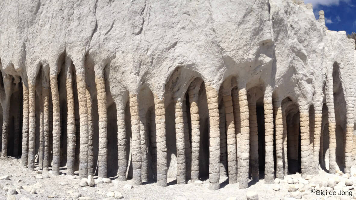
The monster’s maw or mother nature’s art? The Crowley Lake columns.
An exceptional set of circumstances due to an artificially created reservoir has resulted in exposing a fascinating and unique natural feature that was obscured for thousands of years under the earth. The Crowley Lake Columns were slowly unmasked by the powerful waves of the lake pummeling the softer rock of the cliffs. Researchers have only recently begun to study this unique natural phenomenon and one scientist said, “From the very first moment I laid eyes on this weird and wondrous place a year ago, I was smitten. It made me go back to school to get a master’s degree in geology.”
According to a recent study, researchers from UC Berkeley have determined, “that the columns were created by cold water percolating down into — and steam rising up out of — hot volcanic ash spewed by a cataclysmic explosion 760,000 years ago.”
Access to the pillars is by boat, on foot, or 4×4 vehicle and then only in the warmer months of the year when lake is not frozen, and the ground not covered in snow. Once there, though, it almost appears as if an alien life form is growing out of the sand and creating a dark labyrinth into which one might just disappear … forever.
Bishop Information Center
The Bishop Information Center, located at 690 N. Main St. in Bishop, is not so weird, but it’s wonderful how much information you can find there. Our knowledgeable and friendly information center staff can help you pick your path. They can supply directions and maps, brochures, and links to more material online, and tell you much more about all these and other fantastical places to visit in the Eastern Sierra.
Yep. There’s even more out there in this weird, wild, and wonderful world of ours.
And YOU can pick your path!