OWENS RIVER GORGE
The Owens River Gorge is a steep canyon cut by the Owens River. It is California’s most concentrated sport climbing area, located just north of Bishop, and provides nearly 1000 routes. Year-round fishing opportunities too!
Land Manager: City of Los Angeles—Department of Water & Power.
Directions to Trailhead: Take Highway 395 north from Bishop Chamber of Commerce about 12.1 miles to Paradise exit and turn right on the Gorge Road. At the T intersection, turn left (north) on the paved road for about 3.25 miles. Turn right and drive for about 400 feet. Park on the road shoulder before the road barricade. From here, hike down the road 1.5 miles just past the power plant to the climbing area. Much of this area is bolted. Keep dogs on leash as you walk into the canyon to avoid accidents with occasional maintenance vehicles. Great for bikes & stroller access.
To reach the central gully (most direct route), continue up the paved road from the 3.25 mile mark for about 1.5 miles. Turn right and travel 0.3 miles to a parking area near a large power transmission pole. The trail is immediately north of the parking area. The trail is very steep, rugged, and loose but provides quick access from the top of the gorge.
Hiking Distance/Elevation/GPS Coordinates: About 1.5 mile approach to climbing area from parking area. 5,397 feet (1,605 meters)
Road Access—Lat.: N 37.4912; Long.: W -118.5635.
Central Gully—Lat: N 37.5100; Long.: W -118.5715.
Misc: Camping is prohibited on City of Los Angeles’ land. Inexpensive camping is available at PV Pit, Horton Creek, and others. Stop by the Bishop Chamber of Commerce and Visitors Bureau at 690 N Main for locations.
Don’t forget to pickup the guidebooks! Owens River Gorge Climbs by M. Lewis and Bishop Area Rock Climbs by P. Croft & M. Lewis. Also, this blog article on the Owens River Gorge is worth checking out.
ALABAMA HILLS
The Alabama Hills is a surreal landscape of mountainous craggy boulders, towers, and pinnacles framed by Mt. Whitney and the High Sierra. The highly fractured and clustered hills of orange rock attracted early 20th century movie producers and continues as a major film production location today. Easy and moderate climbing routes on quartz monzonite are next to the parking areas. Rock quality ranges from quality patina to chossy. Tread lightly. About 300+ routes have been established, the majority being bolted.
Land Manager: Bureau of Land Management—Bishop Field Office. Los Angeles Department of Water & Power.
Directions to Trailhead: From the Bishop Chamber of Commerce, proceed south on Main Street (Highway 395) for 60 miles to Lone Pine. Turn right (west) at Whitney Portal Road. Proceed 2.75 miles to Movie Flat Road. Turn right heading north for 1.5 miles on this road until it turns sharply right and left. Take the left turn and drive on the good quality road for about 0.6 miles to the Loaf Parking Area which contains a large dark rock overhang. Park in disturbed areas only, not on plants. Although area plants may appear dead, they are actually alive. Short walking trails lead to several climbing locations nearby. Please pack out all trash..
Hiking Distance/Elevation/GPS Coordinates: Several climbing areas exist in the Alabamas. Many are located west of Movie Flat Road and only hundreds of feet from nearby parking. The parking area for the Loaf Climbing Area is 4,783 feet in elevation. Lat.: N 36.6081; Long.: W -118.1338.
Misc: Check out Elevation, a mountaineering shop in Lone Pine with maps, climbing guides, and technical gear. Learn about hidden climbing gems, places to camp, and alternative recreation opportunities from shop staff. Pick up the Alabama Hills Recreation Map which identifies popular climbing locations. Camp only in nearby campgrounds including Tuttle Creek, Portagee Joe, Diaz Lake, etc. The Mt. Whitney Hostel provides inexpensive climber friendly lodging in Lone Pine.
Climbing Conditions Report
Updated 4/262024 Conditions Report time! With highs in the upper 50’s/lower 60’s, surprisingly pleasant conditions are forecasted ahead as Buttermilk season winds down. It might be a bit gusty so make sure your spotter doesn’t let those pads fly away once you are high off the deck 😬. Until road crews fix access to the Pollen Grains and Get Carter Boulder, please walk from main parking lot by the bathrooms. We will have to restore extensive damage left behind from folks driving around the mud hole. There’s lots of rattlers 🐍 out there so stay alert and keep pets and children closely supervised.
The Pit … Is NOT The Pits – Affordable Camping Near Bishop
Are you looking for camping that’s near the world-class recreation of Bishop? Look no further than the Pleasant Valley Pit Campground. Just north of Bishop and only a half mile off Highway 395, this gorgeous and friendly campground is the perfect spot to base yourself...
Things To Do In Bishop CA In January AKA Juneuary
The best things to do in Bishop CA in January translates to ALL season fun. Or as we like to call it, “Juneuary” is your chance to have your cake and eat it too in a mountain getaway. Be it snow-free or an all-weather variety vacation, Bishop’s big backyard is THE place to visit in winter.

RESOURCES FROM YOUR LOCAL CLIMBING RANGERS
- About the Bishop Climbing Ranger Program
- Support the Bishop Climbing Rangers – DONATE
- Bishop Climbing Coalition
- BLM – Bishop Field Office
- Inyo National Forest
- Camp Like a Pro
- Friends of the Inyo
- Bishop Airport
- Bouldering Pad & Climbing Shoe Rentals
- Rock Climbing Guides
Sierra Mtn. Guides // Sierra Mountain Center
Campground Beta
Coming to Bishop and want to camp? There are a lot of campgrounds with great amenities in Bishop! Here are some to keep in mind:
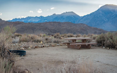
⛺️ The Pit Campground – the pit is the classic Bishop camping zone – conveniently located near the Happy and Sad boulders with quick access to the 395. For $5 a night you get a campsite with a great view, access to toilets, dumpsters and fire pits, and is a great place to meet climbing partners if you are traveling solo! No reservations required
⛺️ Browns Campgrounds – Brown’s has campgrounds all over Bishop, and their spot in town, “Browns Town” is a great option for warmer months as most of their spots are grassy and shaded! Open March 1st – Nov 30th, they have electricity, hot showers, clean restrooms, coin-op laundry, and amazing homemade pie in their general store. What’s not to like? This is a great spot if you have an RV or trailer, and costs around $30/night to stay
⛺️ Tri-County Fairgrounds – want to camp in town?? Tent camping costs $15/night at the fairgrounds on a grassy setting and includes showers and electricity! No need to reserve in advance unless for an event or a large group
⛺️ Inyo County Campgrounds – these campgrounds are open year round, cost $14/ night, with reservations and walk-ins accepted. There are no hook ups at these campgrounds. Visit inyocounty.us for more info!

PINE CREEK CRAGS
Pine Creek Crags is a stunning high wall slot canyon located in Pine Creek Canyon northwest of Bishop. This granitic canyon contains several high wall routes for the avid mountaineer.
Land Manager: Inyo National Forest—White Mountain Ranger District.
Directions to Trailhead: Take U.S. Highway 395 north about 10.5 miles from Bishop Chamber of Commerce to the Rovana turnoff (Pine Creek Road). Turn left on Pine Creek Road. Proceed 7.8 miles from this turn. You will pass the Rovana community as you head into Pine Creek Canyon. At the 7.8 mile mark, you will see a narrow high walled canyon known as Pine Creek Crags off to your right. Look for the small parking area on the right side of the road after you pass the canyon. Park here and hike up the narrow 4 wheel drive route which heads uphill and northerly to the mouth of the canyon. The route narrows into a single track hiking trail near the canyon entrance. Many sport routes dot Sheelite Canyon, between the classic crack climbs dating back to the 1970’s. Please pack out all trash.
Hiking Distance/Elevation/GPS Coordinates: About 1/3 mile approach to climbing area from parking area. 6,893 feet (2,100 meters) at parking area.
Lat: 37.3807; Long: W -118.6733.
Misc: Eastside Sports and Sage to Summit, two outdoor alpine shops in Bishop, provide technical gear, climbing books, clothing, and information on Eastern Sierra mountaineering venues. Their staff has scaled mountain peaks, walls, and boulders in this region of limitless outdoor possibilities.
WHITNEY PORTAL
“. . . The grandest climbing arena on the entire east side” is how Bishop Area Rock Climbs, the Eastern Sierra’s definitive guide to climbing, describes Whitney Portal. Its grandeur, views and sheer immensity overwhelms your senses. Granite cliffs pierce the sky projecting over a thousand feet upwards. Splitter finger cracks; long arching corners; and bulging white faces with black knobs make up the area’s routes. There are some 55 bolted routes with slab face climbing and 100+ trad routes. Parking is limited because the area is popular with hikers and backpackers.
Land Manager: Inyo National Forest—Mt. Whitney Ranger District.
Directions to Trailhead: From the Bishop Chamber of Commerce, proceed south on Main Street (Highway 395) for 60 miles to Lone Pine. Turn right (west) at Whitney Portal Road. Drive 11.1 miles to Meysan Trailhead Parking. The second parking area is 0.3 miles further; the third parking area is another 0.6 miles. The road ends here below the waterfall.
Hiking Distance/Elevation/GPS Coordinates: Meysan Lakes Trailhead Parking Latitude: N 36.5903; Longitude: W -118.2273. Second parking area lies next to Wood Road (dirt) and across from the Whitney Group Campground. Latitude: N 36.5884; Longitude: W -118.2339. Mt. Whitney Trailhead Parking is at 8,317 feet (2,535 meters) – Latitude: N 36.5868; Latitude: W -118.2397. Please pack out all trash.
Misc: Stop at the Whitney Portal Café, a favorite of alpine climbers. Local owners, Doug and Earlene Thompson, have catered to mountaineers and backpackers alike for decades. Doug, a climbing legend himself, is the guru of local mountaineering lore. Ask him about routes, hidden gems and other opportunities for mountain adventure. Stock up on carbs before your climb with their pizza-sized pancakes— the biggest in the world!
How to be a Conscientious Climber
 Bishop area climbing has continued to grow in popularity. Making sure use is sustainable is important to keeping these areas from being loved to death. Land management agencies are sometimes bound by lengthy processes that can hinder their ability to mitigate negative impacts. Responsibility rests on the shoulders of the climbing community. We are all in this together.
To avoid a tragedy of the commons, we must do our part to tread lightly at our local climbing areas and make a commitment to keeping to the seven Leave No Trace principles:
Plan Ahead & Prepare
Some of the roads leading to our climbing areas are rough (i.e. Buttermilk Road). Make sure you are prepared for the conditions of these roads. Cracked oil pans, damaged suspension, and other issues are not uncommon. When conditions become snowy/icy, vehicles frequently get stuck – and tow services can be very expensive.
Drive slowly on all dirt roads. High speeds create damage to the road base. Speeding on dirt roads is also a safety concern for yourself, for other drivers, and for the pedestrians that use these roads.
Weather conditions in this region often change quickly. Make sure you have researched the weather forecast and are prepared. Bishop is known for its arid climate with wide-ranging highs and lows. During the winter season, it’s common to feel hot in the sun and cold in the shade. Windy conditions can also create problems – sand in the eyes or blown away tents and campsite items. Injuries have also resulted from crash pads being blown out from under falling boulderers.
It is important to be prepared for when nature calls. If a toilet is unavailable at your destination, be sure to use a wag bag and pack out all waste (including toilet paper).
For additional information, contact the Bishop Visitor Center.
Camp and Travel on Durable Surfaces
If you are planning to camp, please use established campgrounds. The Pleasant Valley “Pit” Campground is an excellent option with maintained toilets and excellent views. Open from September to May, the sites at the Pit do not require reservation, are affordable, and can accommodate larger groups. You can also get a permit to extend your stay if you wish to stay longer than 14 days.
The Tri-County Fairground is another good option – with camping close to town. Sites include showers and electricity – and can be reserved (but reservations are not required).
Dispersed camping is very delicate in the Bishop region. It is recommended to use an established campground. Areas that have been used for dispersed camping have become degraded with human waste and other trash. It is important to both park and camp only in the areas that have already been impacted. Some folks decide to park a little further into the brush or to place their tent outside the impacted area – expanding the sites by compacting topsoil and hindering plant regrowth.
Dispose of Waste Properly
Pack out all of your trash and dispose of it in a proper receptacle (this usually requires carrying your trash back to town). Unless you are at an established campground, there are no trash services at any of the climbing areas. Used toilet paper or orange peels, for instance, will not biograde until well after they become a nuisance for someone else. If we wish to sustain these natural landscapes, we need to do our part to pack out our waste.
For human waste, use an established toilet/porta-john (like the ones at the Buttermilks or the Happies trailhead). If you don’t have access to an established toilet, use a wag bag and pack it out with your toilet paper. These areas are far too popular to bury waste. Buried waste and used toilet paper often reemerges in very unpleasant ways.
Leave What You Find
You may find something of natural beauty that you want to take with you. Make sure to leave these items so the next person may also find the same joy when they discover them.
You may also find crafted rock or a shard of obsidian, for instance. If you find anything like this please leave them where you find them. These items are protected cultural resources that are historic to the native people that have roamed these lands for generations.
We strongly suggest you visit the Paiute Shoshone Cultural Center to learn more about the history of these lands and its people.
Minimize Campfire Impacts
What is the difference between a campfire and a wildfire? Your skills and how responsible you are. A single mismanaged and mishandled campfire can destroy our vulnerable landscape.
Use only existing fire rings and do not expand or modify these fire rings. Do not scavenge from the landscape for material to burn. Plant life may appear dead, but it is in fact alive and dormant. Before leaving any fire unattended, the fire must be put out – this means cold to the touch. Have extra water with you for that purpose.
Learn how and when to have a campfire responsibly by getting a free campfire permit. A California Campfire Permit is a required permit for campfires on any public lands – including campfires in established campgrounds. Better yet, consider not having a campfire. Most of the time, a campfire is not necessary. Consider how important a campfire is to your experience before creating one.
Respect Wildlife
All kinds of wildlife roam these areas. Respect their home. Give all wildlife their space – keep control of pets (always leash pets in high use areas), and avoid quick movements/loud noises. Also, be sure not to leave out food and pack out all trash (especially human waste).
Be Considerate of Others
Respect the experiences of others while climbing. Drones, unruly dogs, playing music, and large groups can all have an impact on others’ experiences. You can do your part by striving to reduce loud noises and keeping your party-size small.
There are many boulders in every main area. If a party is at a boulder that you want to climb at, consider going to another boulder that isn’t occupied. If you can’t do that, ask them if you may join – and accept that they may ask for you to wait. While you might be driven toward your ticklist, understand that others may be enjoying their space. At the same time, no one has a claim to any route, boulder, or problem. If you are nested at a popular boulder or at the base of a classic problem, respect that others also deserve the opportunity to climb there. In any case, be considerate and maintain respect. If the feeling of solitude in the outdoors is important to you, avoid taking trips on holidays and weekends. The Buttermilks, the Happies, and Sads are all often well-visited during these times.
Park respectfully. Do not create a bottleneck on any roads (if a large emergency services vehicle cannot comfortably pass around your parked vehicle, that is a bottleneck) and do not make your own parking spot by parking on top of any plant life. If neither of these can be achieved, park elsewhere and walk. The mild inconvenience of walking a longer distance can help to reduce big issues and help to prevent negative perceptions of climbers.
It is important to recognize and have consideration for all people, not just climbers. Many different user-groups and members of local communities often enjoy the areas around where we climb. Actions of climbers inform their perceptions of the climbing community. These perceptions are often what inform decision-makers. If the climbing community is respectful and considerate, that goes a long way. We are all in this together. There is a lot of nuance to each principle and we all need to do the deeper work of understanding how to reduce our impacts with informed decision-making. If you haven’t already, familiarize yourself with Access Fund’s Climber’s Pact and dive deeper into climbing ethics.
Last but not least, if you are traveling to the Bishop area or to other rural areas to climb – consider the local gateway communities that you may be passing through. Many rural communities lack resources and are often neglected by visitors passing-through to their destinations. There is a lot you can do to help – regardless the duration of your visit:
– Support local businesses and artists in the towns you are visiting. Instead of buying everything from the nearest city and driving in, consider buying goods locally. Bishop has plenty of grocery stores and restaurants, and some excellent shops that feature works of local artists.
– Support local nonprofits. Consider supporting youth/cultural organizations (such as AkaMya Cultural Group), local domestic crisis centers (for instance, Wild Iris), search and rescue teams (i.e. Inyo County SAR), local climbing organizations (like Bishop Climbers Coalition), or one of the many other area environmental/social nonprofits that are doing meaningful work (such as Friends of the Inyo or Eastern Sierra Interpretive Association). Do some research. Your contributions are meaningful.
– Expand your circle. Step outside the climbing scene and explore different activities, restaurants, shops, and events. Take the time to visit the Paiute Shoshone Cultural Center, hire a fishing or mountain guide and spend a day on the river or in the backcountry, or visit some of the unique events in the region or shops on Main Street. Connect with people from the local community with openness and learn about their ways of life and the things that are important to them, without judgment. Sierra Mountain Center and Sierra Mountain Guides have superior reputations for great alpine guide services in the Eastern Sierra.
Are you willing to stand up for our climbing areas?
As climbers, we have a personal stake in the health of our outdoor landscapes – without them, we have no place to climb. But as our sport continues to grow in popularity, we are loving our climbing areas to death. Join us in protecting our outdoor landscapes and the climbing experience we love. Making a few minor adjustments to your climbing practice is easy to do and will help protect climbing areas for the long haul.
COMMIT TO THE CLIMBER’S PACT:
- Be considerate of other users
- Park and camp in designated areas
- Pack out all trash, crash pads, and gear
- Dispose of human waste properly
- Stay on trails whenever possible
- Respect wildlife, sensitive plants, soils, and cutural resources
- Place gear and pads on durable surfaces
- Clean up chalk and tick marks
- Minimize group size and noise
- Learn the local ethics for the places you climb
- Respect regulations and closures
- Use, install and replace bolts and fixed anchors responsibly
- Be an upstander, not a bystander
#VISITBISHOP GUEST EXPERIENCES
**Make sure to tag your Instagram and Facebook photos with #VISITBISHOP so we can find them!!