“Listen to the wind, it talks. Listen to the silence, it speaks. Listen to your heart, it knows.” ~ Native American Proverb
Itinerary ideas for a quick outdoor adventure break in the Eastern Sierra
On the east side of the mighty Sierra Nevada is a deep, beautiful valley known to the first people of this region as Payahuunadü, which means “land of flowing water.” Today it is more commonly referred to as the Owens Valley.

Our big backyard. Looking south over Buttermilk Country from the Tungsten Hills.
Sweeping views. Big mountains. Fresh air. Sunshine. Burbling streams. Blossoming woodlands. Trails that weave through alpine forests and around sparkling blue lakes. Rivers and streams that create verdant paths down rocky canyons and across high-desert plains. Boulders that can be climbed. Waters that can be fished. A canopy of stars that shines at night, brighter than at almost any other accessible place on earth. Home to the planet’s oldest living things. It sounds like paradise. It is. And we call it our big backyard.
Bishop is world renown for many outdoor activities such as fishing, rock climbing, trail running, and landscape photography. It’s also an amazing place for cycling, off-highway driving, stargazing, and auto touring. Plus, there are a lot of great learning experiences in the form of natural and cultural history. In our big backyard, you only need an hour for a rewarding outdoor experience, but if you have more, we can open a door to the vast playground that is our big backyard.
The itineraries below give a few suggestions for each of these activities within a set time frame. If you find yourself in Bishop with an hour or four to spare, this is the resource that can quickly and accurately get you out and about without wasting a minute.
For the sake of consistency, the starting point for each adventure is placed at the intersection of Main St and Line St in downtown Bishop and the drive time stated includes there and back plus a few minutes of prep as might be needed. Note also that the activity time is a time allowance, and the nature of your group or the speed at which you and your party walks, runs, or cycles should be considered before undertaking one of these adventures. If your time limit is strict, please review the information below carefully and be sure that you can not only do the activity in the time allowed, but that you’ll have a rewarding and enjoyable experience.
As always … ask us if you any questions. Call us at (760) 873-8405 or come on into our visitor center at 690 N. Main Street in Bishop. Our staff is friendly and knowledgeable and can give you maps and brochures and help you make an informed decision.
Most importantly, whenever you go for an outdoor adventure in the Eastern Sierra, tell someone where you are going and when you’ll be back. Remember to check-in with them afterwards. Always wear sunscreen, carry more than enough water and snacks, take layers for changes in elevation and because the weather is pretty unpredictable, do your research and have a plan. Now go on out there and …

Choose your own adventure
Click on each toggle bar below to open a whole world of possibilities for …
1-Hour Experiences
Fish – Owens River
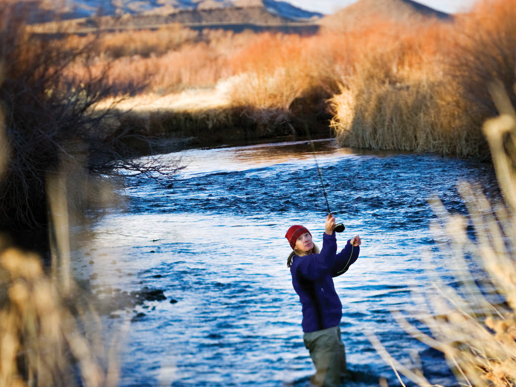
Along the river.
A mere 3-miles and 5-minute drive from the center of Bishop is the closest access point to the swift, sweeping turns of the Owens River. To clock at least 45 minutes of superb fishing at this beautiful spot have your gear ready and take a quick drive east on E. Line Street, which begins at the junction with Main Street in downtown. At exactly 3-miles, just as you crest a low rise and see the bridge over the river ahead, slow down, look right and turn right onto a broad dirt road. In 400 feet park on the edge of the clearing or curve left to drive up to the riverbank.
Fishing! On a wild river, weaving through the scrub of the vast high desert plains of the Eastern Sierra. A backdrop of the White Mountains rising over 10,000 feet above. In only one hour! It’s sublime and serene.
This is especially fun for a quick outing with kids. Review our blog about getting kids ready for fishing here. Fishing is legal and wonderful all year on the lower Owens River. Be prepared with plenty of water to drink and full sun protection gear especially in summer, but also in winter. We have an average of 335 sunny days a year.
Drive time: 15 minutes.
Adventure time: 45 minutes.
Best time: Late spring afternoon.
Trail run – Bishop Canal loop

Spring along Bishop Canal
One thing we know about runners is that a daily run is an absolute necessity. We have so many great trail runs here that you may want to come back often just to try them all out. If you’re a competitive runner this is an excellent place for high altitude training. And, for all the ultra-runners out there, this is the location of the Bishop High Sierra Ultra. It also has a couple of great fun runs on the schedule, so there’s something for everyone.
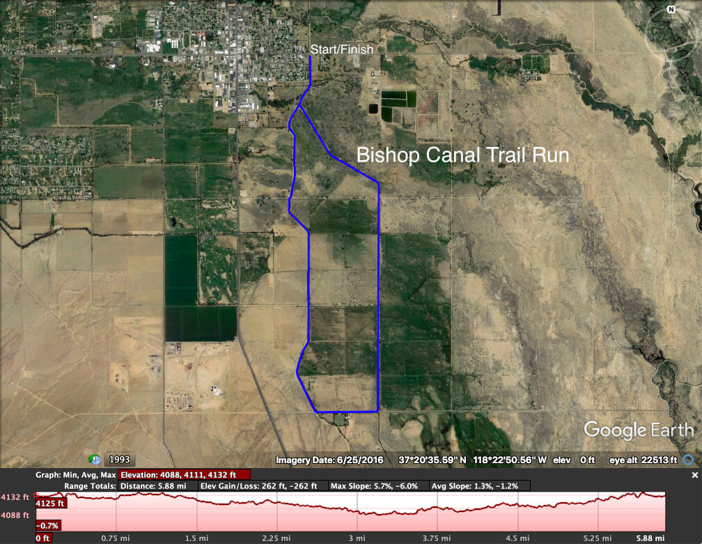
Bishop Canal trail run map and profile
Now when all you have is one hour, here’s the run to do. The Bishop Canal run. This loop route is just under 6-miles on graded dirt road, with a short 0.4-mile paved bit, and very little elevation change. It’s a picturesque route that’s easy to find and easy to do. From the intersection of Main and Line Streets downtown, head east on E. Line St for a half-mile to the outskirts of town. Just as you cross the bridge over the canal turn right and park in the clearing to the left. Go through the turnstile and run alongside the canal. At 2.65-miles you’ll come to the short, paved section. Turn left onto Warm Springs Rd. and in 0.4 miles turn left onto another dirt road. A long and lovely straight section flanks another cool canal. At mile mark 4.7 the canal and track curve left and at mile 5.5 you’ll be back on the track you started on. Turn right and in a ¼-mile, you’ll be back at your car. See the map here to review this route and plan accordingly. (You could just run here and back from wherever you’re staying town.)
This is a great run any time of year, especially in the early morning or late afternoon.
Drive time: 5 minutes.
Activity time: 55 minutes.
Best time: Late afternoon in late fall when the old cottonwood trees are changing color.
Auto Tour – South Lake

South Lake road near Tyee trailhead, late afternoon early fall.
The proverbial Sunday Drive can be done any day of the year in Bishop. There are wonderful places to visit with a quick auto tour, from winter drives around the valley floor to the changing colors of the season in fall in the high Sierra Nevada.
A lovely drive of about an hour, during the warmer months of the year, up to South Lake in Bishop Creek Canyon can feel like a wilderness adventure. In fact, it is. Most of the terrain you’ll see on either side of the road is designated wilderness and there are magnificent views of the craggy peaks rising dramatically above the lake at the road’s end.
At the junction of US 395 (Main St.) and W. Line St., head west on W. Line St. (SR-168 W.) and wind your way up the canyon for 15 miles. Turn left onto S. Lake Rd. and cruise up to the turnaround and parking area for the trailhead. Park and take a few minutes to stretch your legs and soak up the sights, sounds, and smells of the alpine environment at this elevation of 9,750 feet above sea level.
Fall is the most spectacular season up here, and if you plan on doing some leaf peeping and photography you may want to allocate more than an hour. But for a quick tour and spectacular mountain scenery, this is the drive to do whenever the road is clear of snow and open. Spring is blooming marvelous!
Drive time: 1 hour.
Activity time: 1 hour.
Best time: Late afternoon in early fall.
Walking Tour – Bishop Murals

Mural of the 20-Mule Team.
Scenes of the past and notable moments of history in the Owens Valley are depicted on the exterior walls of many buildings throughout Bishop. Historically accurate and visually beautiful murals can be seen along an easy walking route through downtown. In an hour or less you can stretch your legs and let your imagination wander back in time as these beautiful works of art conjure up images of what life was like in this high desert community.
Start your tour from wherever you happen to be stopped or staying in town and choose the direction and pace to suit yourself. The murals project began in 1997 when the Bishop Mural Society was established, “to display our heritage in a spectacular outdoor art gallery surrounded by natural beauty.” Today there are fifteen murals, the most recent of which is made up of 421 sculpted ceramic tiles and mosaic, created by 216 community members. Pick up a map at the Bishop Visitor Center or follow the links online on the society’s webpage.
Drive time: None.
Activity time: 1-hour.
Best time: A clear spring day when the snowy peaks of surrounding mountains provide a stunning natural backdrop.
History Tour – Laws Railroad Museum

Laws Depot
This wonderful museum celebrates the rich history of the early settlers of the Owens Valley and tells of a time when the railroad station was the heart of a bustling western town. The Laws Railroad Museum is located 5-miles north of Bishop on US Highway 6, where the site covers eleven acres of land that formed part of the original Laws Railroad depot.
Close to 50 authentic structures house artifacts and original objects that depict the lifestyles of the homemakers, artisans, and townspeople of the period. Most of these objects of antiquity are the actual tools used by the practitioners of their crafts such as, newspaper publishers, gold miners, ranchers, blacksmiths, dentists, physicians, and pharmacists who lived and worked here. All the historic buildings are original structures and some, like the Laws Depot, the Agent’s house, the locomotive turntable, and the oil and water tanks were constructed right here and have stood on this site since the first train rolled in, in 1883.
Read more about the Laws Railroad Museum here and the history of the railway known as the Slim Princess here.
Drive time: 15 minutes.
Activity time: 45 minutes.
Best time: Fall afternoon when grass is still green and air is cool.
2-Hour Experiences
Road bike – Warm Springs loop

Biking the Laws Poleta – Warm Springs Loop
This is an excellent loop of about 15-miles that has minimal elevation gain and loss – just 790ft. Ride it at an easy cadence for a relaxing and energizing outing or push hard for an energetic workout. There are a number of start and end points and you can go at it clockwise or counterclockwise. Whichever you choose the views are marvelous as you roll across the river and ride along the base of the White Mountains.
A great place to start this ride is from the east side of Bishop City Park. Review the full description of the ride hereon our comprehensive road biking page. This is a superb ride any time of year.
Drive time: 15 minutes.
Activity time: 1 hour & 45 minutes.
Best time: A warm winter day.
Hike – Druid Trail

View of Bishop from the Druid Trail
If you have a little time and lot of tenacity this fairly strenuous hike to the Druid Stones delivers a bird’s eye view of Bishop and the Owens Valley below. The hike follows a very obvious trail from the base of the Coyote Ridge just off Bir Road, about 5 miles from the center of Bishop. From the intersection of Main and Line Streets, head west on W. Line St. for 1.5-miles. Turn left onto Barlow Ln and 1.6 miles further keep right onto Bir Rd. In 1.8 miles park on the sandy shoulder near an obvious dirt road. If you have an all-wheel or 4-wheel drive vehicle with high clearance, turn onto the dirt road and follow it to the base of the hill where the trail beging.
The trail climbs about 1,700 feet in a little under 2 miles. The stones are a well-liked bouldering area, but not often frequented by climbers because of the relatively long and steep (by climbers’ standards) ascent to the boulders. It’s excellent exercise for regular hikers and nimble trail-runners almost any time of year. Winter can drop a good blanket of snow on the upper parts of the trail and it can get icy too. Take care.
For a complete overview and detailed directions to trailhead take a look at our guide to the Druids Trail here.
Drive time: 20 minutes.
Activity time: 1 hour & 40 minutes.
Best time: A sunny spring afternoon when small wildflowers will scent the air sweetly.
Mountain Bike – McGee Creek, Buttermilk Country

McGee Creek Trail with view Mt Tom
Go for a solo or group ride and get your MTB fix on this great 5-mile mountain bike loop trail. It begins about two miles along Buttermilk Rd. and weaves around the creek and an area of hillside the southern side of the road. Drive west from Bishop on SR 168 W. (W. Line St.) for about 7-miles and turn right onto Buttermilk Rd. Drive a further 1.8 miles and just before the road crosses McGee Creek turn right on a narrow dirt road and park in the clearing to the left.
Take a look at the full description for this ride here and check even more great rides on our comprehensive mountain biking page here. The route is not too technical, but one steep, sandy descent of about 40 feet could be daunting for a novice. The rides out here are best in spring and fall and a dry winter.
Drive time: 40 minutes.
Activity time: 1 hour & 20 minutes.
Best time: A sunny spring day after a rainstorm when the sand is damp.
Fish – Buckley Ponds

Buckley Ponds with view of the Sierra Crest
Fishing is legal all year along the lower Owens River. The river is cold and swift and by contrast the tributaries and ponds are warm and gentle. The Buckley Ponds just east of Bishop is a series large maintained ponds along Rawson Canal. It’s a short drive from Bishop to the shores of these lovely ponds, where fishing can yield bass, bluegill, carp and even catfish. Large piers have been built over the water to provide wheelchair access for disabled individuals and safe places for children from which to fish.
Pack a picnic, and even if it’s winter pack sunscreen and sun protection, a couple of chairs and of course your fishing gear. From the junction of Main St. and E. Line St., drive east on E. Line St. At exactly 2.3-miles, 500-feet beyond the cemetery, turn right onto a dirt road that is indicated by one large, lone cottonwood at the junction. Follow the canal road for 2.5-miles until you reach the series of three ponds. Altogether this is a 15-minute drive, which leaves 1.5 hours for fishing and the return trip of 15-minutes. Of course, stay longer if you can, but if you crave a quick fishing outing and all you have is 2-hours, this is it!
Read more about this place of flowing water here. If you or members of your party have disabilities take a look at this article about wheelchair accessible places in the Eastern Sierra.
Fishing in the Buckley Ponds is open and accessible all year. These ponds have a couple of nice access points for a cooling a dip or splash on sunny summer day, but the super summer swimming is in the crystal clear lakes higher up the mountains. Take a look at the Summer Splash in our 4-Hour Adventure Itinerary here.
Drive time: 30 minutes.
Activity time: 1 hour & 30 minutes.
Best time: A warm winter day.
Auto tour – Lake Sabrina

Blue waters of Lake Sabrina
Lake Sabrina, pronounced Suh-BRY-nuh (no-one knows why – it just is) is a gorgeous, blue lake that sits at just over 9,000 feet above sea level. The stark granite peaks of the Sierra Nevada, rise above the alpine forest that surrounds the lake. The lake level fluctuates seasonally and annually, but the beauty of the area never diminishes. A quaint café and beautiful boat landing alongside the dam are open and accessible by road and, in addition to the photography opportunities here, the homemade pie and ice cream are the reason why this is a 2-hour adventure.
From the junction of US 395 (Main St.) and W. Line St. (SR-168 W.) head west on W. Line St. for 19 miles, a 25-minute drive. Park in the turnaround at the road’s terminus, or continue around to the overflow parking just few feet back down on the left. Take a walk across the dam then seat yourselves at a patio table or inside the café and enjoy a treat in the rarified mountain air. This is a truly magnificent and relaxing afternoon break.
Access to Lake Sabrina is open from late spring to late fall, depending on when the winter snow comes down and when it’s cleared.
Drive time: 1 hour.
Activity time: 1 hour.
Best time: It’s a tie. A hot summer day when the lake is sparkling blue and the forest is emerald green. A late fall afternoon when the forest turns to gold and swaths of brilliant color appear to flow out of the rock toward the deep blue water like lava.
Stargazing – Buttermilk Country

An early night sky from Round Valley
A late-night adventure is pure magic in the Eastern Sierra, which still boasts incredibly dark, clear skies. It’s so impressive that we have a whole page and night sky guide dedicated to stargazing in our big backyard. Heading out after dark is an astronomical learning experience and it’s easy and safe to do with the whole family.
Even though the starry, starry night is quite obvious from anywhere in town, get just a little further from the city lights for a mesmerizing view of the Milky Way. A 12-minute drive will get you to one sweet spot on Buttermilk Rd., where there’s a soft, sandy embankment to spread a blanket and gaze at the stars in wonder.
Drive west on SR 168 (W. Line St.) for 7.3 miles and turn right onto Buttermilk Rd. Drive 0.6 miles and turn left onto dirt track up to a large clearing. It’s a perfect slope to get a good view of the sky above and a sweeping vista from the Sierra Nevada to the west, north over the Tablelands, and east to the White Mountains. Lie down on the soft dirt, take a deep breath, and just look and listen.
The canopy of stars is astonishing any dark night of the year. Winter provides more clarity at night because the air is cold and dry, but the Milky Way is below our horizon. This magnificent ribbon of stars arcs highest across the sky from the southwest to the northeast from late summer to early fall.
Drive time: 25 minutes.
Activity time: 1 hour & 35 minutes.
Best time: At least one hour after full sunset within a week before to a week after the new moon on a late summer night.
3-Hour Adventures
Hike – First Falls, Big Pine Creek

First Falls, Big Pine Creek.
The hike is a short, easy walk of a quarter mile with less than 200 feet of elevation gain to a beautiful, rushing waterfall in the cool alpine forest of Big Pine Creek. Getting to the trailhead from Bishop is a 40-minute drive into another of our region’s spectacular glacial canyons. The better part of 2 hours of this relaxing adventure will be a winding mountain auto tour. Then take some time along the trail and at the falls to relax your body and ease your mind.
Getting to the trailhead from Bishop, drive south on US 395 for 15-miles and turn right onto W. Crocker Ave. The road becomes Glacier Lodge Rd. and ends at the trailhead 10-miles further and almost 4,000 feet up. Follow the trail from the parking area for just over 1/4-mile to a sturdy footbridge over the falls. Extend the hike as long as you have time for, by crossing the bridge and wander a little way up the trail as it climbs alongside the creek to second falls. Review the trail details on the hike to first and second falls in Big Pine Canyon and learn more about the waterfalls of our big backyard in this comprehensive guide to waterfalls in the region.
Turn this adventure into a vacation when you stay at Glacier Lodge or camp in the Big Pine Creek Campground. This is a magnificent canyon of lakes and waterfalls, just like so many of our glacial canyons in the Eastern Sierra. Winter snow will close or limit access to the canyon so check current, local conditions before you go.
Drive time: 1 hour & 30 minutes.
Activity time: 1 hour & 30 minutes.
Best time: Late spring during the wildflower bloom.
Road bike – Round Valley / Pleasant Valley loop

Quiet country road biking with incredible scenery in Round Valley
This is a ride that has a little of everything in just the right measure. It has uphills and downhills, sharp corners and sweeping bends. You’ll work hard enough to stay warm, but not so hard that you can’t lift your head and admire the awe-inspiring views. It’s about 18 miles of quiet country lanes and a pleasant, car free ride along the shores of the Pleasant Valley Reservoir. There are a number of good points along the route where you can park a car safely to ride this loop. It really is a very pleasant ride!
A great place to start and end the route is at the Millpond Recreation Area, about 7 miles west of Bishop just off US Highway 395, on Sawmill Rd. There is plenty of parking and the amenities include restrooms, picnic area, and a playground. It’s a perfect starting point especially if you’re with a group and not all are cyclists. Depending on your group and ride speed, this ride (including drive time) can be done in under two hours. But it’s also a great ride to go it slow, soak up the scenery, and enjoy the facilities at Millpond.
Other start/end points are at Pine Creek Rd junction with Highway 395, Gorge Rd & Old Sherwin Grade junction (just off Highway 395), or the Pleasant Valley Dam parking area. Take a look at the full route description here and check out some of the other great road rides in our area on this comprehensive road biking page. There are so many incredible road bike rides that once you ride one, you’ll want to ride them all.
Do this ride almost any time of year. The high desert cools dramatically overnight in summer and a dawn ride is exquisite as the rising sun paints the crest of the Sierra pink.
Drive time: 30 minutes.
Activity time: 2 hours & 30 minutes.
Best time: Late afternoon in spring when lingering wave clouds on the mountains glow orange and pink.
Mountain bike – Lower Rock Creek

Lower Rock Creek trail ride in early fall.
Got 3 hours to spare? This incredible single-track trail is the pièce-de-résistance of mountain biking in Bishop. The route has 3 stages of excellent downhill trail, with the first two stages running alongside Lower Rock Creek and its namesake road that weaves down this beautiful canyon. The upper trailhead is located at the top of Lower Rock Creek Rd. at its junction with US 395 near Tom’s Place. From here there are two options for riding this trail.
To ride this route solo or with a group, do sections 1 and 2 as a loop – down the single-track trail and back up the road to your vehicle. Any moderately skilled and experienced rider can handle this ride at a relaxed pace. If you and your pack are the fast and furious MTB type, you could squeeze the ride into an hour – averaging 10mi/hr down the trail and 5mi/hr up the road is what you’ll need to do. But that leaves almost no time for soaking in the scenery, which is quite spectacular here.

Lower Rock Creek trail loop
Now, if you have a designated driver (designated to shuttle mountain bikers that is) this amazing ride can be done from top to bottom in 3 hours (including all the drive time.) Begin at the upper trailhead as described above, then follow the entire trail all the way to the lower trailhead. While riders swoop down the trail, your designated driver cruises down the winding road, up through the cutting to crest the rise at the top of the plateau above Swall Meadows, then follows the ribbon of road down the escarpment to Paradise – the small settlement where the lower trailhead is located. The drive is as beautiful and impressive as the ride. Note that the full trail is best for riders with more advanced MTB skills and experience.
Review this map for details about the loop option so you can plan the ride accurately. Take a look at more trail details here and, for lots more mountain biking options, review our dedicated mountain biking page here.
The trail is rideable almost all year long, but a deep winter snowpack near the top may render it inaccessible in some winter months.
Drive time: 1 hour.
Activity time: 2 hours.
Best time: Early afternoon in fall.
Fish – Intake Two

Sweet summer picnic spot at Intake Two
Over two hours of high elevation lake fishing in Intake Two is pretty much a perfect outing. This beautifully maintained reservoir has all the rustic amenities an avid angler could want or need. Paved road access, plenty of parking, a wheelchair accessible fishing pier, a trail all the way around the lake, vault toilets, picnic benches, trees, and regular seasonal fish planting of catchable rainbow trout.
The drive from Bishop takes 20 minutes and it’s a straight shot – no, make that a wonderful winding drive – west up SR 168 (W. Line St.) to the reservoir nestled in Bishop Creek Canyon. Sitting at an elevation of just over 8,000 feet, this is the place for a quick escape from the heat of summer in the Owens Valley.
The lake is usually accessible all year, depending on the snowpack, but fishing is only allowed during sport fishing season and licenses are required. Make sure to check out all rules and regs here. Licenses can be purchased in many Bishop stores. The California Department of Fish and Wildlife (CDFW) offers two Free Fishing Days a year. Check it out. Get started.
Drive time: 40 minutes.
Activity time: 2 hours & 20 minutes.
Best time: A midsummer day is perfect, but can be crowded. Any early morning in fishing season is magic.
OHV – Tablelands

The Headless Miner of Chidago Canyon
Off highway vehicle adventures are hugely popular in our big backyard. And because our backyard is so big, it’s possible to get out there and see very few other people or vehicles. A legal system of roads and trails for motorized vehicles was designated here in 2009 following many years of inventory and analysis. This included public involvement to balance the needs for recreational opportunities and to protect the unique character of our public lands. The result is an extensive network of 2,200 miles of OHV trails and roads providing access through almost one million acres of the Inyo National Forest.
One wonderful route that’s accessible most of the year (winter snowpack may create some limitations at the higher elevations) is north of Bishop on the escarpment we call the Tablelands. It is not a highly technical OHV route, but it’s still best to be fully prepared in a 4×4, high clearance vehicle with the skills and experience to handle an off-highway adventure.
This route is almost 60 miles long and will take you up near Casa Diablo mountain, through the narrows of Chidago Canyon – check out the headless miner – then down the long, historic track that’s known as Fish Slough. It’s a good three hours of driving adventure. There are numerous tracks and trails out here, and it is very easy to get lost, so download this route guide and gpx file to make sure you stay on track.
Begin at the Bishop Visitor Center at 690 N. Main St., and chat with our friendly, knowledgeable staff. Let our folks know where you’re going, ask about current weather conditions, get maps, brochures and any other info that might come in handy. Take a look at these pages for more 4×4 adventure ideas and OHV and auto touring in our area. Always tell someone where you are going and when you expect to be back and then check-in with them when you’re safely back.
Drive time: 3 hours.
Activity time: the same 3 hours.
Best time: Daytime in early spring when the wildflowers are blooming on the tablelands.
4-Hour Adventures
Road Bike – Bishop Creek Canyon

Late afternoon in fall in Bishop Creek Canyon
Bishop is the place for high altitude cycling training and a good half day ride is up and down Bishop Creek Canyon. Ride from West Bishop to Lake Sabrina or as far as your time and pace allows. Turn around at any point on the way up. An average up time to the lake is 3 hours and down time is 1 hour, so plan your time accordingly. Or ride between the two lakes which is a 3-hour ride on average. Take a look at our comprehensive Road Biking page here and review these rides in Bishop Creek Canyon.
Once the winter snow is cleared from the roadway, riding up here is great from spring to fall. Whenever you choose to ride make sure to wear layers and bring plenty of water and snacks. In summer the start in Bishop can be hot and in early spring and late fall the upper elevations can be cold. This is a popular travel destination so always be aware of vehicles, pedestrians and animals on the roadway – especially on a late afternoon in fall.
Drive time: 10 minutes if starting in the valley. 50 minutes if starting at one of the lakes.
Activity time: 3 hours & 50 minutes from the valley (this is a fast pace). 3 hours & 10 minutes lake to lake.
Best time: Early fall when the color change is happening up high.
Snow Shoe – Aspendell

Snow shoeing on a sunny winter day
Winter is usually sunny and temperate in town, and it’s often sunny and snowy in the high Sierra. When SR 168 W. is closed beyond Aspendell in Bishop Creek Canyon due to the winter snowpack, the area is a true winter wonderland. There’s no fun like snow fun. If you don’t have snow gear, pop into Eastside Sports where you can rent the gear you need.
This is a great family outing and depending on your group you can stay and play in a localized area near Cardinal Village Resort (and probably visit Santa during the holidays) or snowshoe along the roadway up the canyon.
About 17-miles from Bishop, along SR 168 W. (W. Line St.) is where the road is closed. Park in the big turnout at the gate and follow the road on snowshoes. If the snow is not yet deep it may be best to hike up the road and strap on snowshoes once you reach the big blanket. Just below this high road, in the narrow hanging valley, are Aspendell and Cardinal Village and there’s parking and fun to be had for the whole family here too. If winter has been generous the gentle slopes near Intake II are also a super fun place to sled, build a snow man, or have a snowball fight.
It is especially important when going out for this adventure to tell someone exactly where you’re going and when you’ll be back. And don’t forget to let them know when you’re safely down the mountain.
Drive time: 50 minutes.
Activity time: 3 hours & 10 minutes.
Best time: A full moon night on a clear, quiet winter evening. Start an hour before sunset. It’s really romantic!
Auto tour & short hike – Ancient Bristlecone Pine Forest

An ancient Great Basin bristlecone pine tree
White Mountain Rd., the road to the planet’s oldest living things, is open from late spring to early fall depending on when the snow shuts it down. The Great Basin Bristlecone Pine can survive for thousands of years and they only live at very high elevations in a few scattered places in California, Nevada, and Utah. The Ancient Bristlecone Pine Forest in the White Mountains above Bishop is home to the planet’s oldest of these living trees. One is believed to be already over 5,000 years old, with others at about 4,850 years old and still living. Of course, there are young ones too. The forest is still living and propagating and will probably be here long after we are gone.
Few people in the world will ever see these trees in person, so if you find yourself in Bishop with a few hours to spare, make the pilgrimage to visit the ancient ones. Take a look at our comprehensive Bristlecone Pine page and review the Who & How section carefully.
The drive from Bishop to the Schulman Grove Visitor center is about an hour. From Bishop drive south on US Highway 395 for 15 miles and, just north of Big Pine, turn left onto State Route 168 East. Follow the road for 13 miles then turn left onto White Mountain Rd. Ten miles further you will arrive at the Schulman Grove Visitor Center. On the way up stop at the Sierra View Overlook for a stunning view across the Owens Valley and Sierra Nevada beyond. Spend a little time in the visitor center and watch a great interpretive film about these incredible trees. Rangers and staff at the Schulman Grove Visitor Center present interpretive programs at 11am and 2pm in the summer. If time and energy permits, take the short walk of just less than a mile along the Discovery Trail.
Please note that if you or anyone in your party are unaccustomed to altitude and develop a headache, dizziness, nausea, or appears disoriented make sure to leave the area immediately. By returning to a lower elevation the symptoms should ease quickly.
Drive time: 2 hours.
Activity time: 2 hours.
Best time: A midsummer day.
Stargazing – White Mountains

Ancient Bristlecone Pine and ancient stars. Photo: Tony Rowell
The visitor center in the Ancient Bristlecone Pine Forest will not be open at night, but the stars will come out to greet you. Check out the information above about visiting this area during the day, but start your adventure as the sun sets over Bishop on a new moon night (or near it) in midsummer. Drive even slower in the dark and be very cautious of animals on the roadway.
Bring an evening snack, a thermos with a hot beverage, and layers including puffy, gloves, beanie, and a scarf. At 10,000 feet above sea level it gets cold – even in summer. And bring a good camera, binoculars, telescope, and tripod if you have. You’re going the see the oldest things in the universe as well.
Take a look at our Night Sky guide page and the section on the sky from the forest up here. Note that the visitor center closes at 5pm and the groves are closed from 10pm to 6am. No trespassing please. There are plenty of great stargazing points along the road up here.
Drive time: 2 hours.
Activity time: 2 hours.
Best time: A midsummer new moon night.
A taste of the Tablelands auto tour. Check out 3-hour adventures.
Stats about Bishop, the Owens Valley, and the Eastern Sierra
The Owens Valley is roughly about 100 miles long by 6 to 18 miles wide, with a land area of about 3,330 square miles. It is considered to be one of the deepest valleys in the United States. Situated at an average of 4,000 feet above sea level the valley floor is flanked by two of the highest mountain ranges on the continent. The magnificent and well-known Sierra Nevada rises up dramatically on the west side of the valley to over 14,000 feet. The White and Inyo Mountains are the gentle giants to the east that rise as high in some places.
There is one main highway, US 395, which cuts through the vast plains of uncultivated lands that appear to have had little human interference. The towns are small, few and far between. Bishop is situated in the widest part of the valley at its northern end. It is the largest of the Owens Valley towns, home to about 7,500 residents, and remains a quaint and quiet western-style settlement. Locally owned businesses feature handcrafted products and innovative creations from art and craft to local gastronomy.
What really sets Bishop apart from the many culturally diverse towns in California and the USA, is the opportunity for exploration and outdoor adventure. Bishop is the heart of the Eastern Sierra, a region that comprises two counties, Inyo and Mono, and covers a distance of about 250 miles south to north. Inyo County and its northern neighbor, Mono County, are two of the least populated counties in California. Together these two counties cover just under 10% of the total land area of all of California, with a staggering 99% of land in Inyo County and 93.6% of Mono County designated as public lands.
We call this our big backyard! It is stunningly beautiful and easily accessible. And there’s always time for quick adventure … even a short one!